Originally published in The Midden 11(4), 16-22.
October 1979.
By Grant Keddie
A radio carbon date of 17,000 B,P. on a mammoth bone, the first date from the Saanichton Gravels north of Victoria, provides new evidence that alters the previously suggested timing of glacial events on southern Vancouver Island. The precise timing of these glacial events is of importance for archaeologists because the events define the times during which animal and human populations could have inhabited the Island.
The purpose of this paper is to give a brief overview of what is known about the last stages of the Wisconsin glacial period on southern Vancouver Island; to show how the new radiocarbon date fits into the sequence of events; and to provide a summation of the existing controversy regarding the question of when the predecessors of modern animals came to Vancouver Island.
The Olympia Interglacial and Early Fraser Glaciation
Until lately there has been some uncertainty as to the dating of the last interglacial period (the Olympia Interglacial) and the beginning of the cold period of glacial advances (the Fraser Glaciation). With recent studies a clearer picture is now emerging.
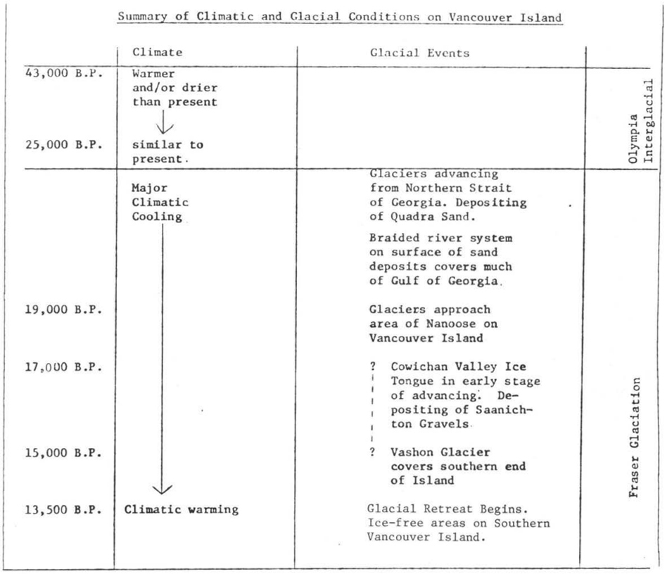
Neville Alley, formerly of the Resource Analysis Branch, Ministry of the Environment, and Keith Valentine of Agriculture Canada conducted studies in the mid-1970s on the sea cliff deposits near Dashwood on the southwestern end of the Island (Alley, Valentine 1977). The samples of ancient pollen which they extracted from these deposits indicated the existence of ice-free conditions between at least 43,000 and 19,000 B.P. The study concluded that the climate in the first part of this period (the Olympia Interglacial Period) was warmer and/or drier than present, perhaps similar to semi-arid areas to the south (see summary diagram). The climate gradually became like that of the present until 25,000 B.P. The period from 25,000 to 19,000 B.P. involved a major climatic cooling. The environment was one of cold grassland conditions, possibly subalpine to tundra. There were scattered clumps of spruce and pine and there was a virtual disappearance of deciduous trees.
Rolf Mathewes of the Department of Biological Sciences, Simon Fraser University, who undertook pollen studies of the Point Grey sea cliffs, also concluded that there was a generally cooler climate than exists at present during the time period around 24,500 B.P., although Mathewes’ interpretation suggests that the climatic conditions were not of alpine severity.
This early cold period after 25,000 B.P. now is considered to represent the first stage of the geologic-climatic period called the Fraser Glaciation. The main event of this period was the Vashon Stade, or glacial advance, represented by a large continental ice-sheet forming in the Coast mountains to the east of Vancouver Island. The Vashon glacier is believed to have eventually overridden the southern end of Vancouver Island. It is the precise timing of this and other events during the Fraser Glaciation period which has yet to be fully explained.
The first evidence of the Fraser Glaciation is represented by deposits found in and along the Gulf of Georgia, called the Quadra Sands. J.J. Clague
of the Geological Survey of Canada concluded from his studies on this sand unit that it formed on outwash plains in front of, and in response to, glaciers advancing into the Georgia Strait. Radiocarbon dates suggest that the Quadra Sands are older than 29,000 B.P. at the north end of the Strait of Georgia and younger than 15,000 B.P, at the south end of Puget Sound (Clague 1977).
The glaciers advancing down from the northern Strait of Georgia had reached the area around Nanoose Bay on Vancouver Island (roughly on the same parallel as Vancouver) approximately 19,000 B.P. At this time another important glacial event was occurring to the south in the form of the Evans Creek Stade or glacial advance. It is represented in Washington State by an advance of valley glaciers from the Olympic and Cascade Mountains into the lowland areas of Puget Sound. The Evans Creek glaciers reached their maximum extent by about 18,000 B.P. and had begun to retreat before the main Vashon glaciation advanced to cover the Puget lowland (Mathewes, Fyles, Nasmith 1970).
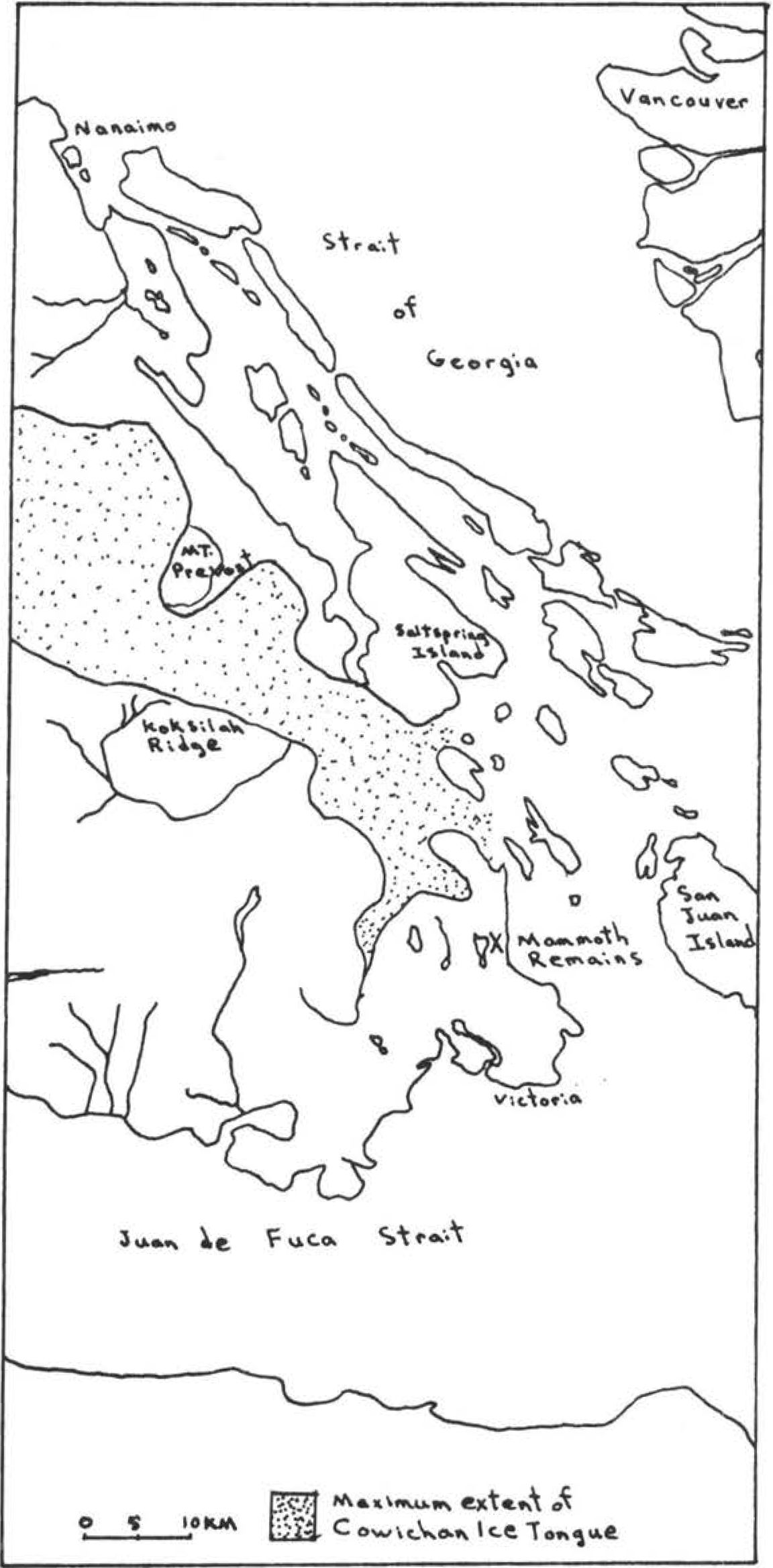
The timing of glacial events on southern Vancouver Island has usually been cross-referenced with events in the Puget Sound area because of the lack of radiocarbon dates from glacial deposits on the Island. One of the important glacial events in this regard is the Cowichan Ice Tongue, which has been assumed to have peaked, like the Evans Creek Stade, at about 18,000 B.P.
The Cowichan Ice Tongue and Saanichton Gravels
The Cowichan ice tongue developed from one of the large alpine glaciers forming in the interior mountains of Vancouver Island. It flowed out of the Cowichan Valley to the southeast, eventually overriding parts of the Saanich Peninsula to at least the area of Bear Hill north of Elk Lake and to the west up Finlayson Arm (Halstead 1968).
Extensive deposits of sand and gravel up to 32 meters thick were built up by meltwater streams emanating from the terminus and sides of the ice tongue. These outwash sand and gravels, called the Cordova Sand and Gravels, or more recently the Saanichton Gravels, are significant in that they have been shown to contain skeletal remains of several large mammals now extinct in the region.
These ice age mammals have been studied and documented by C.R. Harington, Curator of Quaternary Zoology at the National Museum of Natural Sciences (Harington, 1975, 1976, 1977). The most common animal remains have been those of the Imperial Mammoth. One Muskox has been found in the Saanichton Gravels and horse, bison and American Mastodon may possibly be related to these deposits. The precise dating of the Saanichton Gravels and the environment in which they were laid down is important in determining when and under what conditions the last ice age mammals lived on Vancouver Island.
In the past, little detailed stratigraphic information was obtained with the fossil animal finds and no bones or wood material from these deposits had been submitted for radiocarbon dating. In 1975, the author and Neville Alley investigated the finding of a segment of a large mammoth tusk in the Saanichton Gravels at the Trio Ready-Mix Ltd. gravel pit on Cordova Bay Road in Saanich. In 1976 I returned to the same location to examine the finding of a mammoth humerus that was located in the same layer as the tusk. I was able to record the precise stratigraphic location of the humerus and submitted a sample of bone drilled from the inner core of the humerus to Richard Harington, who, with the co-operation of
the Geological Survey of Canada, had the sample dated, The bone sample revealed that the humerus was approximately 17,000 years old,(G.S.C. 2829 17,000 ± 240 B.P.).
The deposits at this location on the east side of Elk Lake form an elongate drumlin-like ridge which is composed of three lithostratigraphic units related to the Fraser Glaciation period. Overlying the fine-to-medium grade Quadra Sands are the gravelly sands and gravels of the Saanichton Gravels. These Saanichton Gravels grade upward into tills that were deposited by the major Vashon glacier which overrode the Cowichan glacier.
The date obtained is significant because it was recovered from the bottom of the previously undated Saanichton Gravels, which in the area of the mammoth remains is found approximately 20 meters (65 ft.) below the surface of the ground. The remains were located within the first meter above the very distinct erosional surface that separate the Saanichton Gravels from the older Quadra Sands below.
E. Carl Halstead of the Department of Energy, Mines and Resources, who studied the evidence left by the Cowichan Ice, notes that radiocarbon dates below glacial material indicate that the Ice tongue moved into the Cowichan Valley at some unknown time after 19,000 B.P. (Halstead 1968). The new mammoth bone date would suggest that the Cowichan Valley Glacier may not have begun advancing or was still advancing south some time after the Evans Creek glaciers in Washington had reached their peak and had begun to retreat.
The Cowichan glacier was advancing after 17,000 B.P. and probably continued to advance until it was overridden by the large Vashon glaciation. The 17,000 year age dates the mammoth and not necessarily the deposits it is in. The mammoth could have died and remained buried further north in non-glacial deposits for a considerable time period and may have later washed out and moved with glacial outwash to the Saanich area. If this was the case, the glaciers may not have reached the area until well after 17 thousand years ago.
Animal Migration to the Island
Now that we are certain large mammals existed on the Island around 17,000 B.P. the question arises as to how these animals, as well as the predecessors of some modern animals, came to Vancouver Island. Harington has suggested that the large animals such as the Imperial Mammoth and American Mastodon could have crossed large floodplains that filled the Georgia Strait previous to the main glacial advance. The Quadra Sands appear to have filled the Gulf of Georgia during the early part of the Fraser Glaciation period. The entire surface of the Gulf was like a braided river channel environment which would have allowed large animals to move across what is now ocean (Harrington 1975).
Harington also suggests that mammals could have crossed land bridges during the height of the last glaciation. He bases the latter suggestion on our knowledge that sea levels were considerably lower during the period of glacial maximum and the fact that the present depth of waters between Vancouver Island, the Gulf Islands and the mainland is relatively shallow in many places, allowing for the existence of land bridges that connected parts of the Island with what is now part of the mainland. He believes that the very existence of a number of endemic mammal species or subspecies, that is, ones that are restricted to Vancouver Island, implies that a suitable migratory route and habitable refugia must have existed on the Island during the peaks of the last two glaciations (Harington 1975, 1976).
Although there is still a lot that we do not know about land-sea relationships during the last glacial maximum, the present geological evidence indicates the land mass of southern Vancouver Island may have sunk low enough under the weight of the ice to equal or exceed the large drop in sea level. Also, glacial erosion on mountains has been interpreted to indicate that the Vashon glacier covered the Victoria area to a depth of 1,000 meters (3,500 ft.) and areas further north near the 49th parallel to a depth of 1,200 – 1,500 meters (4,000 – 5,000 ft.) (Mathewes, Nasmith, Fyles 1970). Land bridges would therefore seem unlikely to have been present during the last glacial maximum.
We cannot, however, completely rule out the possibility that suitable survival areas for animals may have existed along seaward ridges and headlands on the southern west coast of the Island. Ice free areas existed on Vancouver Island prior to 13,000 B.P. (Mathewes, Nasmith, Fyles 1970). If the Vashon glaciation did not cover the Island until about 15 thousand years ago or later we are dealing with a short period of only about 2,000 years or less during which the Island may have been uninhabitable. The short time period of ice coverage may indicate that the thickness of the ice sheet was considerably less than previously thought.
The existence of glacial refugia on southern Vancouver Island and of land bridges or low elevation ice bridges to habitable areas at the beginning of the period of deglaciation seems to be an increasing possibility. Much further research by geologists, paleontologists and archaeologists is necessary to solve the question of how and when some of Vancouver Island’s mammals came here.
References
Alley, Neville F. and Keith Valentine 1977 Paleoenvironments of the Olympia Interglacial (mid-Wisconsin) in Southeastern British Columbia, Canada. Paper presented at the Tenth International Union for Quaternary Research, Birmingham, England, August 16-24.
Clague, J.J. 1977 Holocene Sediments in Northern Strait of Georgia, British Columbia. Geological Survey of Canada, Paper 77-1A, pp. 51-58.
1975 Quaternary Geology, Northern Strait of Georgia, British Columbia. Geological Survey of Canada, Paper 75-1, Part A, pp. 397-400.
Clague, J.J. 1975 Late Quaternary Sea Level Fluctuations, Pacific Coast of Canada and Adjacent Areas. Geological Survey of Canada, Paper 75-1C, p. 171.
Halstead, E. Carl 1968 The Cowichan Ice Tongue, Vancouver Island. Canadian Journal of Earth Sciences, Vol. 5, pp. 1409-15.
Harington, C. R. c.1977 Wildlife in B.C. During the Ice Age. B.C. Outdoors, Vol. 33, No. 6.
1976 Mammoths on Vancouver Island. The Victoria Daily Colonist, May 16.
c.1975 Pleistocene Muskoxen (Symbos) from Alberta and British Columbia. Canadian Journal of Earth Sciences, Vol. 12, pp. 903-919.
Mathewes, Rolf W. 1979 A Paleoecological Analysis of Quadra Sand at Point Grey, British Columbia, based on indicator pollen. Canadian Journal of Earth Sciences, Vol. 16, pp. 847-858.
Mathewes, W. H., J. G. Fyles, and H. W. Nasmith 1970 Post-glacial crustal movements in southwestern British Columbia and adjacent Washington State. Canadian Journal of Earth Sciences, Vol. 7, p. 690-702.