By Grant Keddie. 2013.
Introduction
The Victoria Harbour area, on Vancouver Island, is within the traditional territory of the Lekungen people who are represented by the Songhees and Esquimalt First Nations. In 1843, the Hudson’s Bay Company built Fort Camosun (later Fort Albert and Fort Victoria) in the Harbour. In the early days of this establishment (1843-1855), Clallam First Nations, from the American side of the Strait of Juan de Fuca, set up camps during their trading and employment activities with the Fort.
The location and nature of these camps has been a subject of some uncertainty. But, the location of one of the Clallam camps has been made clear by the finding of unique images located in the Royal Geographical Society of London.
These images were first brought to my attention by Felix Driver of the University of London who was undertaking a study of the drawings of John Linton Palmer (see Driver and Jones 2009). Palmer was an artist on board the HMS Portland visiting Esquimalt Harbour from June 27 – July 4, 1851. He drew several sketches of First Nations camps from Esquimalt Harbour to the Gulf Islands.
The Village Location
Twenty months earlier, on October 10, 1849, Reverend Robert Staines reported the location of a Clallam village in Victoria Harbour:
“On the other side of the Fort within 150 or 200 yards is a village containing a part of a tribe called the Clallums: the great body of whom dwell on the opposite or south side of the straits to which they all belong” (Slater 1950:237-238).
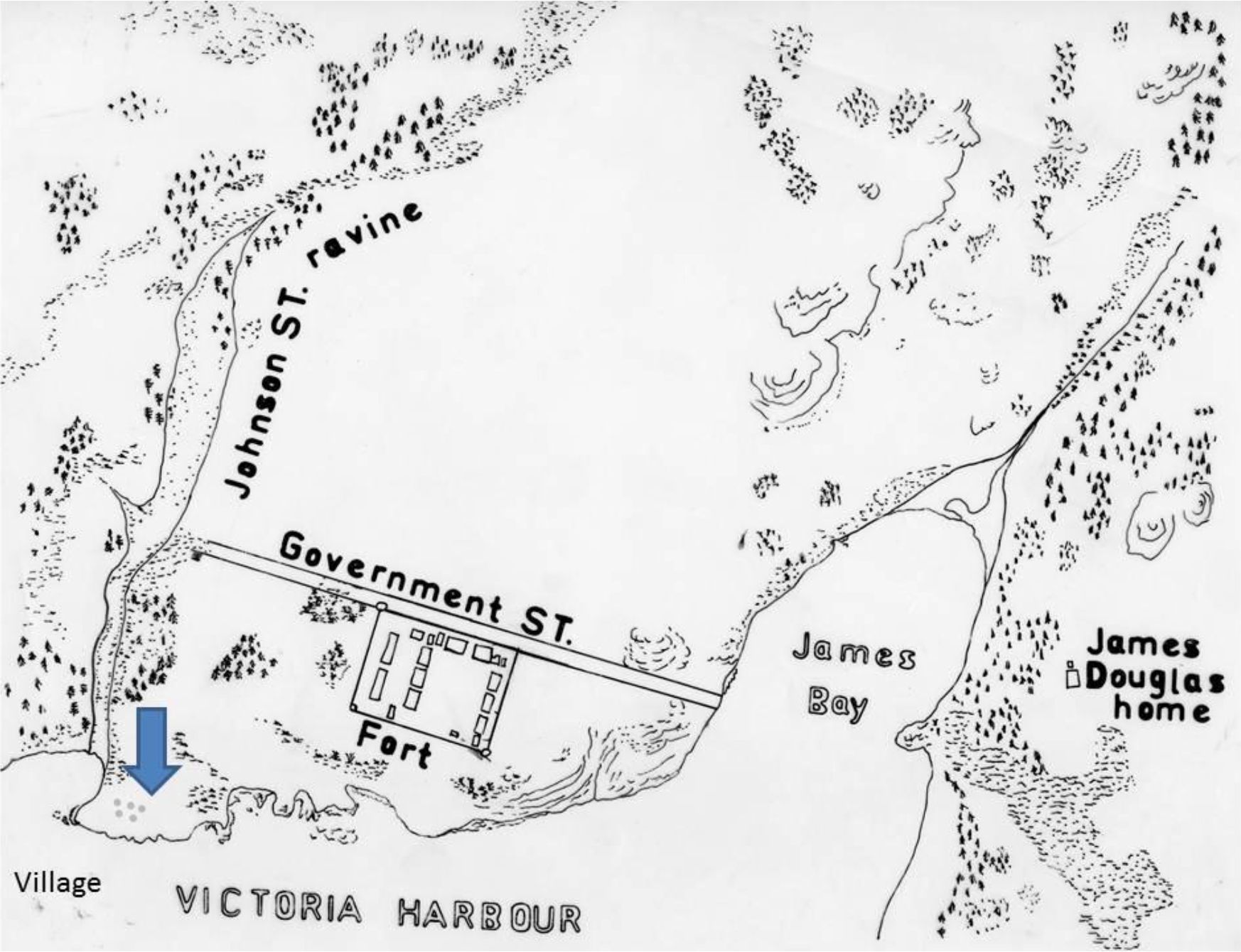
The location that best fits Robert Staines’s description would be north of the Fort above Halkett Head which forms the east end of the Johnson Street Bridge. This location was close to a necessary drinking water source in what was once the Johnston Street Ravine. The location given as 150 to 200 yards north of the Fort would today be on Wharf Street close to the intersection with Johnson Street. This is precisely the scene of Palmer’s drawings (Figure 1&2).
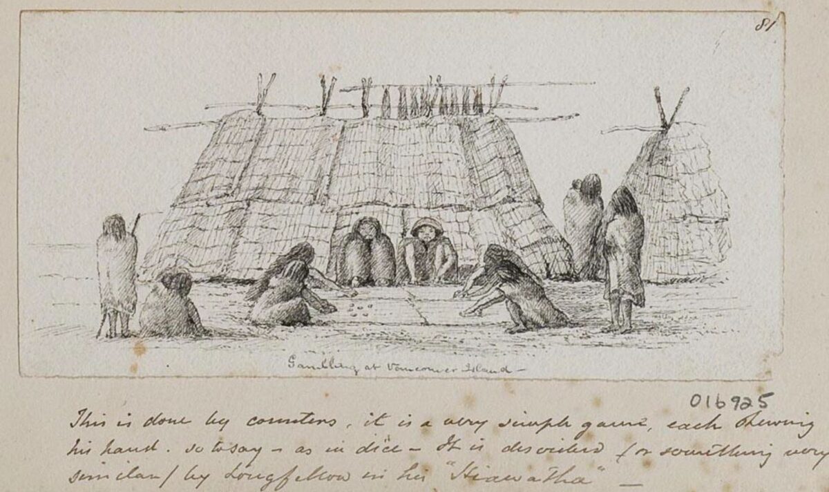
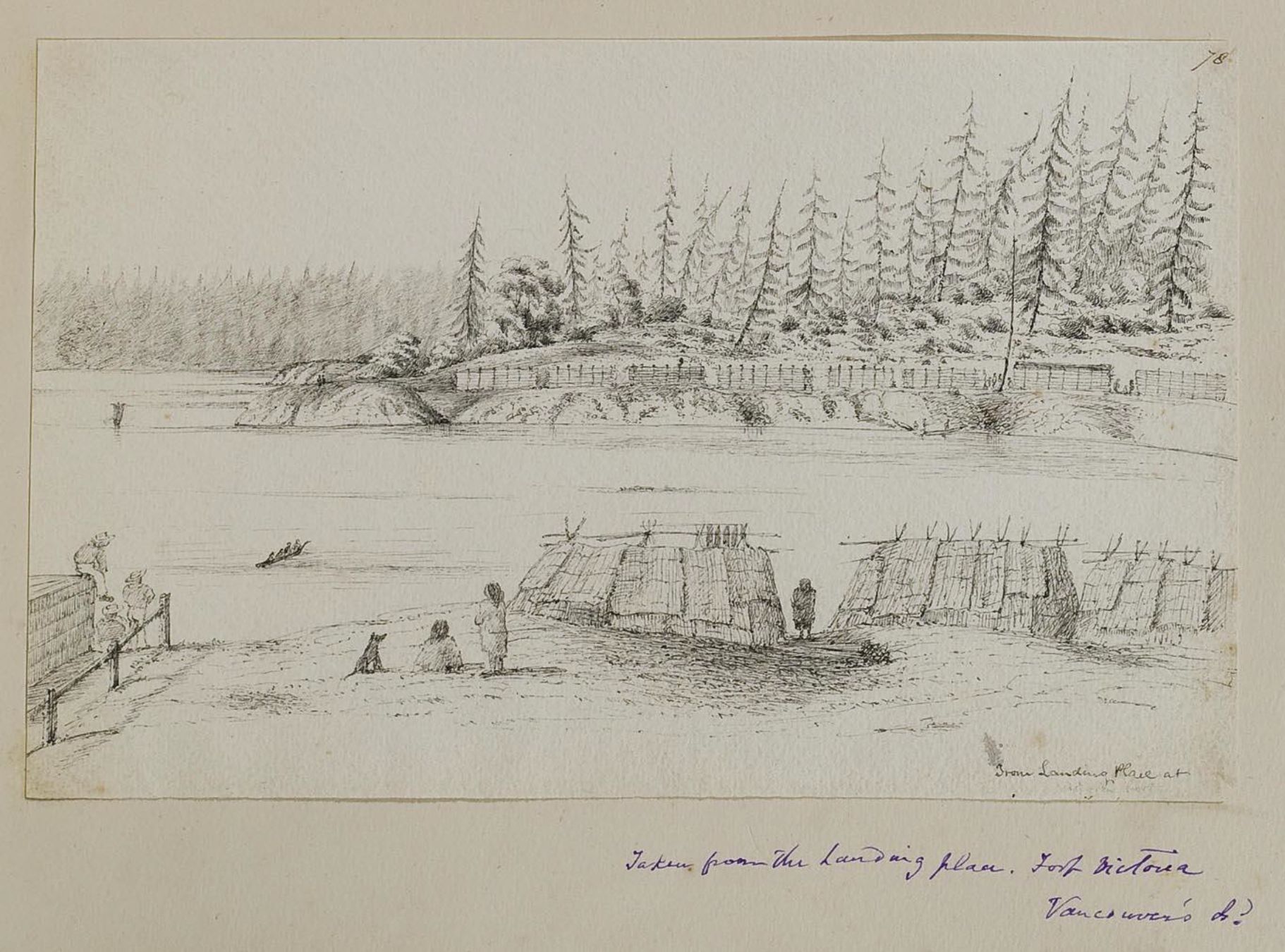
The Palmer Drawing. (RGS – F030/016930).
In this drawing (Figure 1), the Old Songhees Reserve is seen in the background across Victoria Harbour. The part of the village seen here extends from Songhees Point on the left to Limit Point on the right at the western foot of the Johnston Street Bridge – in what is now the community of Victoria West. That is, the Western part of the city of Victoria that extends West of Victoria’s upper Harbour. The area is on the Esquimalt Peninsula, but is not in the Municipality of Esquimalt. Images of this village by the artist Paul Kane have mistakenly been placed in Esquimalt Harbour by previous authors unfamiliar with the area.
In the foreground is a mat lodge camp or “village” – and most likely the one described by Staines as including Clallam people. To the left of the mat lodge village is part of one of the Hudson’s Bay Company storage building that was located above the dock where they landed and transferred goods from their ships.
This drawing is described by Palmer as: “Taken from the landing place Fort Victoria Vancouver Island”. This landing place was at the south end of Halkett Head and below the view of this drawing.
Other Locations of the Village?
I have ruled out other locations pertaining to Staines’s commentary. Considering the same distance from the S.E. or S.W. corner of the Fort would place the furthest distance of 200 yards at Humboldt Street near the north edge of James Bay. The distance across James Bay would be twice as much. Although aboriginal wives later lived with their Hawaiian husbands (who worked for the H. B. Co.) along Humboldt Street, it is not likely that First Nations would be allowed to have a more permanent camp in this area close to active farming operations, and there is no record of such an encampment.
The distance of 150 to 200 yards to the west of the Fort would place the location from just inside the water of the harbour to a location short of the middle on the channel. The distance would be almost twice as much to the other side of Victoria Harbour, where the Old Songhees Reserve was located.
Staines did not say “a Clallam village”, but referred to “a village containing a part of a tribe called the Clallums”. We cannot completely rule out that Staines was referring to the Old Songhees reserve, and implying that some of the houses on this reserve were owned and/or occupied by Clallam people – in addition to the houses of the Songhees. If this was the case however, Staines would have used terms such as “across the inlet, bay or harbour” or referred to the Clallam being on the Songhees Village, but he did not.
The area around the main gate on the east side of the Fort, that is closer to the farming operations, is where most of the activity was in 1849. The statement referring to “the other side” would most likely pertain to the more isolated area north of the Fort. It is at this location where there were earlier lodges in front of the “thick wood between the fort and Johnson Street” that were moved west across the harbour in 1844 (Finlayson, c. 1891:12).
There are no obvious Clallam encampments shown on any of the maps drawn in the 1850-1852 period in the vicinity of the Fort. The 1850, map of Captain Grant (Grant 1850) does not show any, but he also took shortcuts in only showing a representative group – not the true number – of houses labeled “Indian Village” on the Old Songhees Reserve seen in the background of Figure 1.
In 1851, Joseph Pemberton drew a large regional map which included the area around the Fort. This is one he had finished by September 11, 1851. It shows a small square representing a dwelling above the landing dock on Halkett Head. This mark on the map could represent the Clallam encampment but we cannot be certain that it is an out building related to Fort Victoria (Pemberton 1851). Pemberton’s more detailed 1852 map shows a building near the Johnson Street Ravine but it is outlined in red like the other buildings associated with the Fort (Pemberton 1852).

Conclusions
The Clallam from the Port Angeles area were employed over a period of several years by the H. B. Co. on new building projects and farm activities. In April of 1851, James Douglas started a vigorous building program. He employed “100 Indians” in clearing brush and trees and began “putting up buildings about the Fort, having a dwelling House, and a Flour Mill in progress”, erecting a hospital and having plans to erect buildings “for religious and educational purposes” (Douglas 1851). It was only two months after the start of this building program that Palmer drew the mat lodges seen in figure 1. Individual mat lodges may have come and gone, the evidence shows that it is most likely that these unique images preserved by the Royal Geographical Society of London show the location of the Clallam camp described by Robert Staines in 1849.
References
Douglas, James. 1851. Letter of April 16, Douglas to Barkley. In: Fort Victoria Letters, 1846-1851. The Hudson’s Bay Record Society, volume XXXII, pp. 170172. (Ed) Bowsfield Hartwell. Winnipeg. Hudson’s Bay Record Society, 1979.
Driver, Felix and Lowri Jones. 2009. Hidden Histories of Exploration.
Researching the RGS-IBG Collections. Published for the exhibition Hidden Histories of Exploration held at the Royal Geographical Society (with IBG) from 15 October to 10 December 2009. Royal Holloway, University of London, in association with the Royal Geographical Society (with IBG), Kensington Gore, London
Finlayson, Roderick. C. 1891. Manuscript. Autobiography of Roderick Finlayson. British Columbia Archives. N.W. 971.1vi, F512.
Grant, Walter Colquhoun. 1850. Map of the District, Vancouvers Island . HBCA Map Collection, G.1/256. Hudson’s Bay Company Archives. Provincial Archives of Manitoba.
Keddie, Grant. 2003. Songhees Pictorial. A History of the Songhees People as seen by Outsiders, 1790-1912. Royal B.C. Museum, Victoria.
Pemberton, Joseph D. 1851. Victoria District & Part of Esquimalt. J.D. Pemberton, Hudson’s Bay Company Archives A11/73, Fos. Q, 73. B226/6/8. Fo. 18.
Pemberton, Joseph D. 1852. A Plan of the Town of Victoria Shewing Proposed Improvements, 1852. HBCA Map Collection, G.2/38 (T13107). Hudson’s Bay Company Archives. Provincial Archives of Manitoba.
Slater, G. Hollis. 1950. Rev. Robert John Staines: Pioneer Priest, Pedagogue, and Political Agitator. The British Columbia Historical Quarterly, 14:187-240.