Polynesia to British Columbia
By Grant Keddie.
Introduction
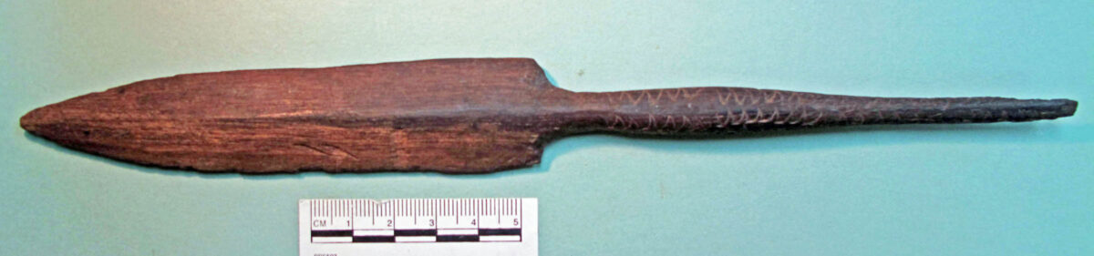
In 1972, I observed the pointed distal end of a broken wooded spear in the collection of the Royal B.C. Museum. Based on its general shape and design patterns, it appeared to be of Pacific Island origin. The wood was most like the Pacific hardwoods Calophyllum inophyllum or Acasia koa. At first, I assumed the artifact must have been buried with some more recent historic debris, but after observing the accession records and talking to the finder, a different picture began to emerge. It was found buried in Tsunami deposits in the Port Renfrew area on the west coast of Vancouver Island. This makes it the first known pre-contact Polynesian artifact found buried in British Columbia.
These deposits were associated with the very large 8.7-9.2 mega thrust Cascadia earthquake of January 26, 1700. The quake’s epi-centre at 45°N 125°W, was located off the west coast of Oregon State. This undersea Cascadia thrust fault ruptured along a 1000 km length, from mid Vancouver Island to northern California. The resulting tsunami spread down the southern western coast of Vancouver Island and across the Pacific Ocean destroying villages along the coast of Japan. Indigenous tradition records the complete destruction of villages close to the shore along the west Coast of Vancouver Island (Atwater 1987; Clague and Bobrowsky, 1994a and 1994b; Nelson, A. R. et al. 1995; Satake et. Al. 1996; Yamaguchi et. al. 1997; Clague, Bobrowsky, and Hutchinson 2000; Atwater et. al. 2003; Satake et. Al. 2003; Nelson et. Al. 2006; Hawkes et. Al. 2011; Wang et. Al. 2013; Hutchinson and Clague 2017).

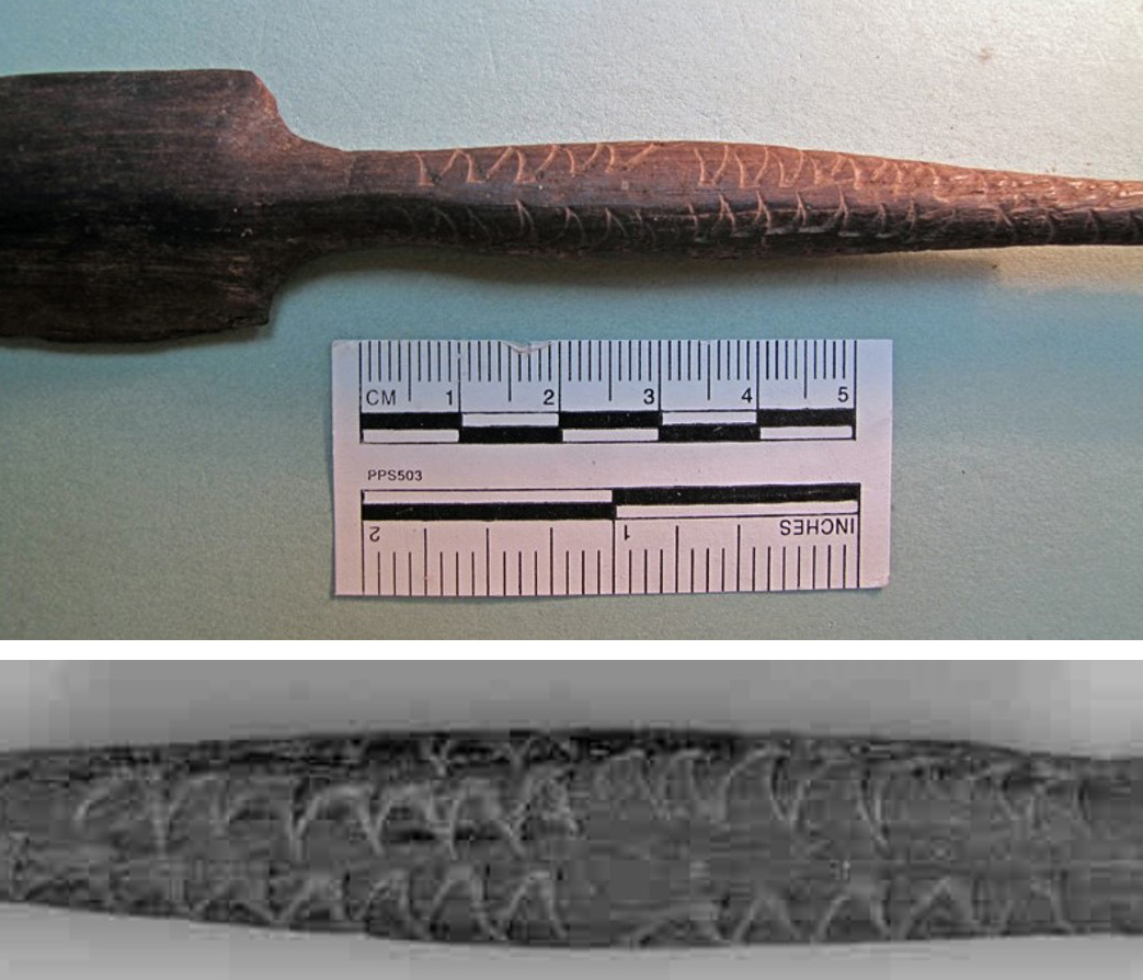
Measurements: The broken tip is 258mm long. The blade is nearly flat on one side and centrally raised on the other. The blade part is 127mm long and 27.3mm wide near the proximal end and 9mm thick. The thicker part of the shaft is 9.7mm wide by 11.2mm high. It weighs 17.35 grams. This portion of the spear may have been socketed into a larger spear shaft.
The Artifact Provenience
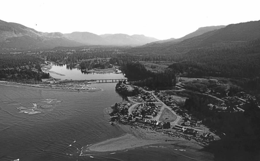
The original RBCM accession record of artifact No. 11617, of July 16, 1962, states that it was found “in posthole 4’ [122cm] deep in beach sand below fill, – below DdSc1”. The latter refers to the archaeological shellmidden site DdSc-1. The artifact was given the number DdSc-1:1, because of its proximity to this site, although the deposits where the spear fragment was found are not part of this site.
The archaeological site is 30-40 feet above sea level. What was locally called “Beach Camp” was below DdSc-1. The latter site is recorded as being “500 yards South West of bridge at mouth of South arm of San Juan River”. It was located on lot 1 in 1980, which is part of the larger lot 158 of the B.C. Provincial Parks Department of Recreation and Conservation map of March15, 1961, Official Plan 16T.1.45T.2, San Juan Pt. 1-1-1-337.
The artifact was found by John “Jack” Joseph Mrus, then living in Port Renfrew. I contacted Jack and his wife Lily in the 1980s when they were living in Departure Bay. He referred to the “arrow” being found on his property when he was digging post holes. He said there was no other historic material only “pure beach sand” at the bottom of the post hole, where the artifact was pulled up with an auger. The location was about 2 meters above the present beach.
All the deposits in this area are tsunami dumped material. See report “Capital Regional District Port Renfrew Tsunami Inundation”. I hypothesized that the spear fragment must have been associated with the 1700 tsunami and would date to the late 1600s.
Radio carbon date
I sent a 100mg sample from the broken end of the spear to Beta Analytic for a standard AMS analysis. The sample, Beta – 288803 DdSc-1-#1 produced Conventional Radiocarbon Age of 210+/-40 BP and a Measured Radiocarbon Age of 260+/- 40 BP. The 13C/12C Ratio is -28.2 0/00. The Intercept of radiocarbon age with calibration curve: Cal AD 1660 (Cal B P 280). [The 2 sigma calibration: Cal AD 1640 to 1690 (Cal BP 310 to 260) AND Cal AD 1730 to 1810 (Cal BP 220 to 140) Cal AD 1920 to 1950 (Cal BP 30 to 0)].
Wood identification
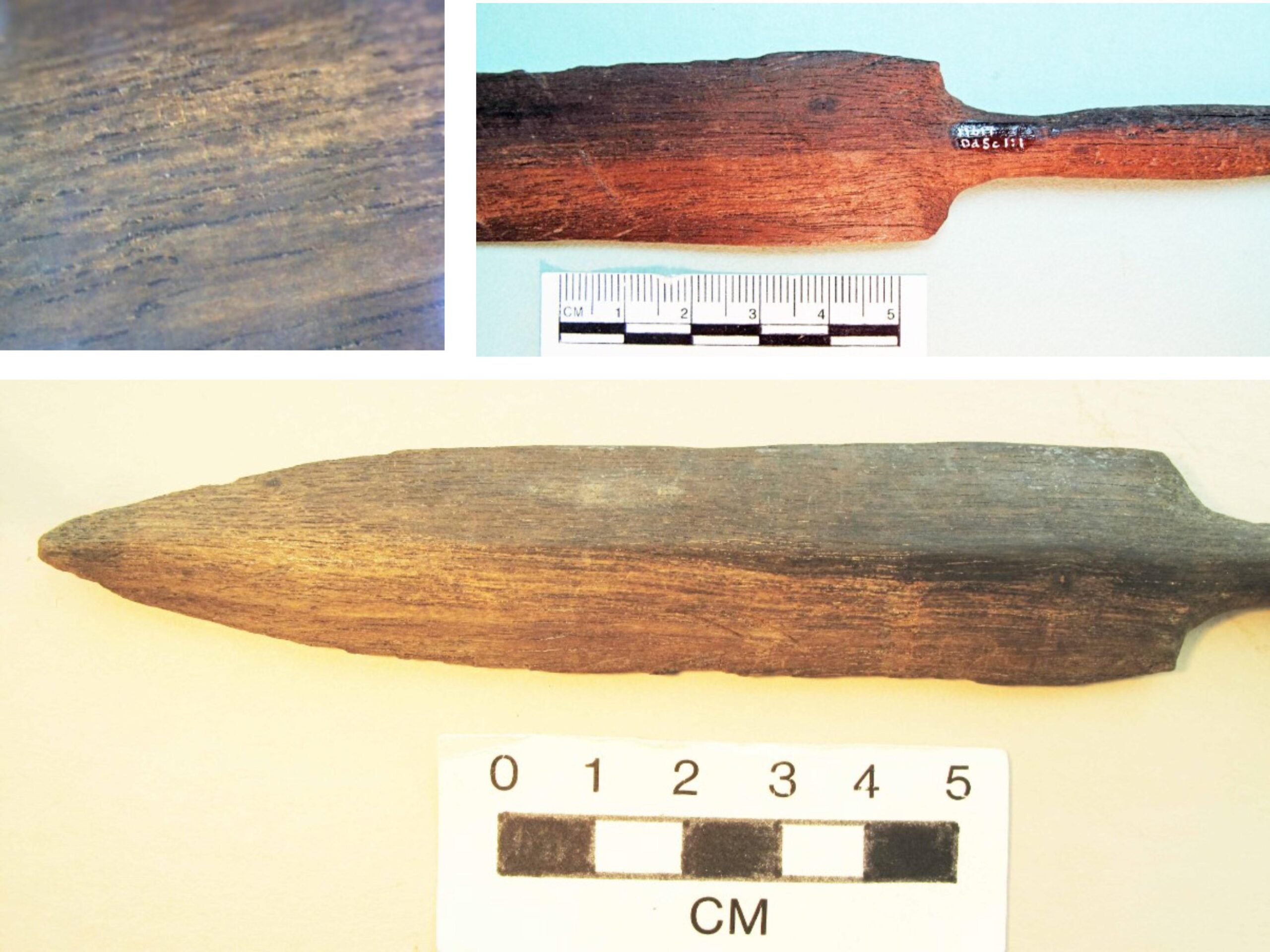
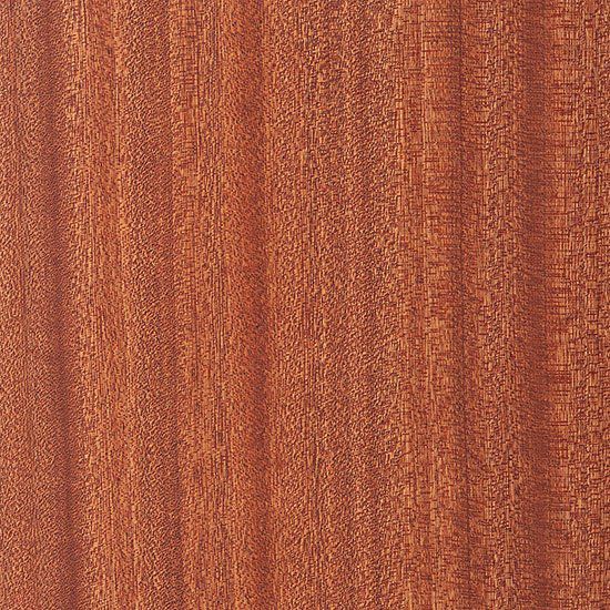
The wood of the artifact is difficult to identify due to the enormous physical variations in the more commonly used Pacific Island plant species (Hoadley 1990 and 2000), but also due to the fact that there is some chemical alteration of the artifact surface due to weathering. The two likely woods used include the Acasia koa (family Fabaceae) restricted to the Hawaiian Islands and the very wide spread Calophyllum inophyllum wood often referred to as Polynesian or Pacific Mahogony. Figure 6, shows a well-defined version of Calophyllum inophyllum wood grain.
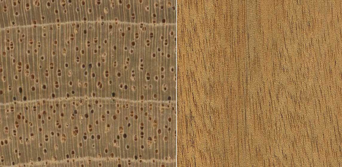
The name Mahogony is often freely used without regard to the proper botanical designation. Woods in the Swietenia genus comprise what is often called “genuine Mahogany”. Swietenia macrophylla has been considered a true Mahogony. All Swietenia species have marginal parenchyma when viewed on the end grain. There are rows of light brown cells at the border of every growth ring that resemble, but are not, annual growth rings (Figure 5 left). Flat sawn surfaces of wood show ripple marks (rays or reddish-brown slits), collectively arranged in little rows which appear as minute little ripple marks (Figure 5 right). Some species can be darker red with dark streaks and other paler and lighter in weight (Meier 2024).
In 1778, in Hawaii, James King wrote: “Their instruments of wars are spears …of two sorts, and made of a hard solid wood, which has much the appearance of mahogany. One sort is from six to eight feet in length, finely polished, and gradually increasing in thickness from the extremity till within about half a foot of the point, which tapers suddenly” (Cook and King 1784).
Calophyllum inophyllum is a large evergreen plant, commonly called mastwood or beach calophyllum. It is called tamanu, in the Cook Islands and French Polynesia, dilo in Fiji and fetau in Samoa. Calophyllum inophyllum is widespread, being native to parts of East Africa, southeast and east Asia and the Islands Indonesia, the Ryuku Islands of Japan, Malaysia, Papua New Guinea, the Philippines, Sri Lanka, Taiwan, the Cook Islands, Fiji, Marquesas and Society Islands, Guam, the Marshall Islands, Micronesia, the Northern Mariana Islands, Palau, Samoa and the Northern Territory and Queensland of Australia.
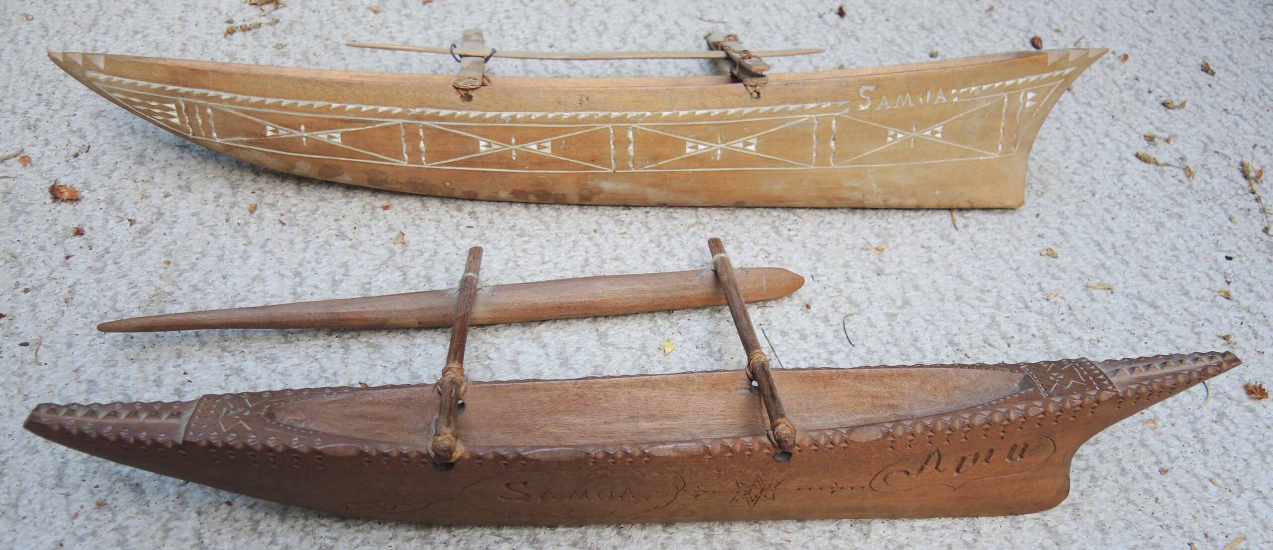
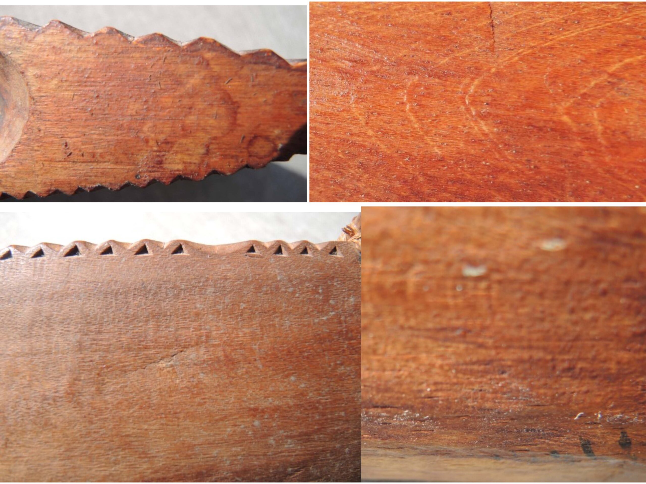
The source of the wood would be easy to identify if it proved to be from the Acasia Koa plant which is endemic only to the Hawaiian Islands. Like other parts of Polynesia, the trunks of this tree were used to build dugout outrigger canoes, surf boards, furniture, bowls, weapons, fishing equipment, drums and ritual objects like the Tiki figures. Figure 7, shows model canoes made for the tourist trade that were made from Calophyllum inophyllum wood, often referred to as “Polynesian Mahogany”. The grain patterns are difficult to identify on historic artifacts that are typically make of Calophyllum inophyllum – as can be seen in figure 8. Appearance differs with colour and wood density.
Discussion
Over the centuries, tsunamis have caused devastation in the Pacific Islands. It is most likely that tens of thousands of wooden artifacts have been washed into the sea and sent by currents in many directions. Many of these may have made their way across the Pacific, being waterlogged at sea or washed onto the shores of the western coast of North America. Any of these floating in the water or submerged on the beaches could have been thrown ashore by the large tsunami of 1700 A.D. or earlier. More large tsunamis have occurred in the past. A very large tsunami occurred about 2800 years ago that may have been larger than the tsunami of 1700 (Atwater et. al. 997; Benson et al. 1997; Shennan et al. 1998; Clague et. al. 1999; Hutchinson et. al. 2000; Blais-Stevens & Clague 2001; Kelsey et. al. 2002; Witter et. al. 2009; Peterson et al. 2013; Graehl et. al. 2015; Garrison-Laney 2017; Garrison-Laney & Miller 2017; Goff et. al. 2020; Nelson et al. 2020; Nelson et. al. 2021; Tanigawa et. al. 2022).
One may wonder how artifacts washing ashore on the Pacific coast of North America over the centuries would have been viewed by local indigenous peoples who found them. Would they have copied the shapes or designs on the artifacts and become part of local traditions or to have stimulated stories about people that lived across the Ocean?
Conclusions
I have radio-carbon dated the spear to the most probable date of 1640 A.D. This, and its buried context, confirms its association with the Tsunami event of 1700. As the wood has not been positively identified by electron microscope or isotopic analysis, this it something that should be done in the future. DNA and isotope analysis may pin down the source of the spear wood to a specific Island in Polynesia. If the wood proves to be from the Acasia koa tree, we will know its source is Hawaiian.
References
Wood Identification References
Cook, James and James King. 1784. A Voyage to the Pacific Ocean. Vol. III, pp. 151-52, London.
Hoadley, R. Bruce 1990. Identifying Wood. Accurate Results with Simple Tools. The Taunton Press.
Hoadley, R. Bruce 2000. Understanding Wood. A Craftsman’s Guide to Wood Technology. The Taunton Press.
Meier, Eric. 2024. The Wood Database. https://www.wood-database.com/wood-articles/mahogany-mixups-the-lowdown/.
1700 Tsunami References (In Time Sequence)
Atwater, B. F. 1987. Evidence for great Holocene earthquakes along the outer coast of Washington State. Science 236, 942–944.
Clague, J. J. & Bobrowsky, P. T. 1994. Tsunami deposits beneath tidal marshes on Vancouver Island British Columbia. Geol. Soc. Am. Bull. 106, 1293–1303.
Clague, J. J. & Bobrowsky, P. T. 1994. Evidence for a large earthquake and tsunami 100–400 years ago on western Vancouver Island British Columbia. Quat. Res. 41, 176–184.
Nelson, A. R. et al. 1995. Radiocarbon evidence for extensive plate-boundary rupture about 300 years ago at the Cascadia subduction zone. Nature 378, 371–374.
Satake, K., Shimazaki, K., Tsuji, Y. & Ueda, K. 1996. Time and size of a giant earthquake in Cascadia inferred from Japanese tsunami records of January 1700. Nature 379, 246–249.
Yamaguchi, D. K., Atwater, B. F., Bunker, D. E., Benson, B. E. & Reid, M. S. 1997. Tree-ring dating the1700 Cascadia earthquake. Nature 389, 922–923.
Clague, J. J., Bobrowsky, P. T. & Hutchinson, I. 2000. A review of geological records of large tsunamis at Vancouver Island, British Columbia, and implications for hazard. Quat. Sci. Rev. 19, 849–863.
Atwater, B. F. et al. 2003. Earthquake recurrence inferred from paleoseismology. Dev. Quat. Sci. 1, 331–380.
Satake, K., Wang, K. & Atwater, B. F. 2003. Fault slip and seismic moment of the 1700 Cascadia earthquake inferred from Japanese tsunami descriptions. J. Geophys. Res. 108, 2535.
Nelson, A., Kelsey, H. & Witter, R. 2006. Great earthquakes of variable magnitude at the Cascadia subduction zone. Quat. Res. 65, 354–365.
Hawkes, A. D., Horton, B. P., Nelson, A. R., Vane, C. H. & Sawai, Y. 2011. Coastal subsidence in Oregon, USA, during the giant Cascadia earthquake of AD 1700. Quat. Sci. Rev. 30, 364–376.
Wang, P. L. et al. 2013. Heterogeneous rupture in the great Cascadia earthquake of 1700 inferred from coastal subsidence estimates. J. Geophys. Res. 118, 2460–2473.
Hutchinson, Ian & John Clague. 2017. Were they all giants? Perspectives on late Holocene plate-boundary earthquakes at the northern end of the Cascadia subduction zone. Quat. Sci. Rev. 16:29–49.
Multiple Tsunamis References (In Time Sequence)
Atwater, B. F. & Hemphill-Haley, E. 1997. Recurrence intervals for great earthquakes of the past 3,500 years at northeastern Willapa Bay, Washington. U.S. Geological Survey Prof. Pap. 1576.
Benson, B. E. et al. 1997. Tsunami deposits beneath tidal marshes on Northwestern Vancouver Island British Columbia. Quat. Res. 204, 192–204.
Shennan, I. et al. 1998. Tidal marsh stratigraphy, sea-level change and large earthquakes II—Submergence events during the last 3500 years at Netarts Bay, Oregon USA. Quat. Sci. Rev. 17, 365–393.
Clague, J., Hutchinson, I., Mathewes, R. W. & Patterson, R. T. 1999. Evidence for late Holocene tsunamis at Catala lake British Columbia. J. Coast. Res. 15, 45–60.
Hutchinson, I., Guilbault, J.P., Clague, J. J. & Bobrowsky, P. T. 2000. Tsunamis and tectonic deformation at the northern Cascadia margin: A 3000-year record from Deserted Lake, Vancouver island, British Columbia, Canada. The Holocene 10, 429–439.
Blais-Stevens, A. & John J. Clague, 2001. Paleoseismic signature in late Holocene sediment cores from Saanich Inlet, British Columbia. Mar. Geol. 175, 131–148.
Kelsey, H. M., Witter, R. C. & Hemphill-Haley, E. 2002. Plate-boundary earthquakes and tsunamis of the past 5500 yr, sixes river estuary, southern Oregon. Bull. Geol. Soc. Am. 114, 298–314.
Witter, R. C., Kelsey, H. M. & Hemphill-Haley, E. 2003. Great Cascadia earthquakes and tsunamis of the past 6700 years, Coquille River estuary, southern coastal Oregon. Geol. Soc. Am. Bull. 115, 1289–1306.
Nelson, A. R., Asquith, A. C. & Grant, W. C. 2004. Great earthquakes and tsunamis of the past 2000 years at the Salmon River estuary, central Oregon coast USA. Bull. Seismol. Soc. Am. 94, 1276–1292.
Kelsey, H. M., Nelson, A. R., Hemphill-Haley, E. & Witter, R. C. 2005. Tsunami history of an Oregon coastal lake reveals a 4600 yr record of great earthquakes on the Cascadia subduction zone. Bull. Geol. Soc. Am. 117, 1009–1032.
Witter, R. C., Hemphill-Haley, E., Hart, R. & Gay, L. 2009. Tracking Prehistoric Cascadia Tsunami Deposits at Nestucca Bay, Oregon. U.S. Geological Survey Award No. 08HQGR0076 Final Technical Rep.
Peterson, C. D., Cruikshank, K. M., Schlichting, R. B. & Braunsten, S. 2010. Distal run-up records of latest Holocene paleotsunami inundation in alluvial flood plains: Neskowin and Beaver Creek, Oregon, central Cascadia margin, west coast USA. J. Coast. Res. 26, 622–634.
Blais-Stevens, A., Rogers, G. C. & Clague, J. J. 2011. A revised earthquake chronology for the last 4,000 years inferred from varve-bounded debris-flow deposits beneath an inlet near Victoria British, Columbia. Bull. Seismol. Soc. Am. 101, 1–12.
Peterson, C. D. et al. 2013. Coseismic subsidence and paleotsunami run-up records from latest Holocene deposits in the Waatch Valley, Neah Bay, northwest Washington, U.S.A.: Links to great earthquakes in the northern Cascadia margin. J. Coast. Res. 29, 157–172.
Graehl, N. A., Kelsey, H. M., Witter, R. C., Hemphill-haley, E. & Engelhart. 2015. S. E. Stratigraphic and microfossil evidence for a 4500-year history of Cascadia subduction zone earthquakes and tsunamis at Yaquina River estuary, Oregon USA. Geol. Soc. Am. Bull. 127, 211–226.
Milker, Y. et al. 2016. Differences in coastal subsidence in southern Oregon (USA) during at least six prehistoric megathrust earthquakes. Quat. Sci. Rev. 142, 143–163.
Garrison-Laney, C. 2017. Tsunamis and sea levels of the past millennium in Puget Sound. PhD thesis. University of Washington.
Garrison-Laney, C. & Miller, I. 2017. Tsunamis in the Salish Sea: Recurrence, sources, hazards. The Geol. Soc. Am. Field Guide. 49, 67–78.
Satake, K., Heidarzadeh, M., Quiroz, M. & Cienfuegos, R. 2020. History and features of trans-oceanic tsunamis and implications for paleo-tsunami studies. Earth-Sci. Rev. 202, 103112.
Goff, J., Bobrowsky, P., Huntley, D., Sawai, Y. & Tanigawa, K. 2020. Palaeotsunamis along Canada’s Pacific coast. Quat. Sci. Rev. 237, 106309.
Nelson, A. R. et al. 2020. Identifying the greatest earthquakes of the past 2000 years at the Nehalem River estuary, northern Oregon coast, USA. Open Quat. 6, 1–30.
Nelson, A. R. et al. 2021. A maximum rupture model for the central and southern Cascadia subduction zone—reassessing ages for coastal evidence of megathrust earthquakes and tsunamis. Quat. Sci. Rev. 261, 106922.
Tanigawa, Koichiro, Uki Sawai, Peter Bobrowsky, David Huntley, James Goff, Tetsuaya Shinozaki and Kazumi Ito. 2022. A new chronology for tsunami deposits prior to the 1700 CE Cascadia earthquake from Vancouver Island, Canada. Scientific Reports Vol. 12 No. 12527.
Clague et. al. 2000. Great Cascadia Earthquake Tricentennial. Geological Society of America. Penrose Conference. Seaside, Oregon, June 4-8, 2000. Conveners: John J. Clague, Brian Atwater, Yumei Wang and Ivan G. Wong. Cosponsored by the U.S. Geological Survey, Geological Survey of Canada and the Oregon Department of Geology and Mineral Industries.
Peters, Robert. Bruce Jaffe and Guy Gefernbaum. 2007. Distribution and sedimentary characteristics of tsunami deposits along the Cascadia margin of western North America. Sedimentary Geology 200(3-4)372-386.