Resources of the Gorge
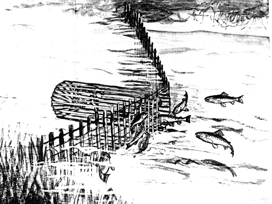
We know that the Gorge must have provided a wealth of resources for the Lək̓ʷəŋən peoples. In 1843 James Douglas noted that the Gorge provided excellent fishing resources. Coho and some Chum salmon ran up the Gorge with the greatest numbers being present in June. Large herring runs came in April and trout were caught by Lək̓ʷəŋən peoples all winter with weir and basket traps on what Douglas called the “Gorge river”. This could refer either to Colquitz creek or the narrow Gorge Falls area of the inlet. Although there are no historic observations of traps in place, it is likely that similar traps were used at a few narrow locations along the Gorge (Figure 1). Chinook salmon could be caught in Victoria harbour and possibly further up the inlet during high tides as James Douglas mentioned that they “enter Camosack” all winter.
Anchovies, now extinct as a Gorge Waterway fish, were once abundant. In 1859, Charles Wilson observed that in October and November: “Herrings and a species of anchovy appear in great numbers” The B.C. Guide for 1877-1878, observed that in autumn, the anchovy: “abounds in the harbours and inlets, and may be taken with great ease in any quantity”. In British Columbia: “This fish is only second to oolachen or hou lican, in its abundance”. Its disappearance occurred with over fishing of trawlers during W.W. 1 (Wilson 1866; Guide 1878; Keddie 2013).
The Gorge was an excellent source of oyster, which preferred the particular water temperature and salinity that exits between the Selkirk Waters and an area east of the Admirals Road bridge (Lambert 1967). Their shells are clearly visible as the largest quantities in the shell middens. Other shellfish species and crabs would be available in some areas and many species of edible plants could be obtained along the shoreline. Both wintering and migrating birds, would form part of the food resources available (Douglas 1843: Keddie 2023).
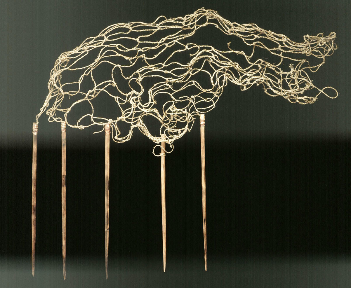
Figure 2, shows a model of a net (C’Quit-Shen Swi/Tun), made of stinging nettle (RBCM 2433). It was commissioned by Charles Newcombe c. 1903, to be of the type with large mesh used for catching Spring salmon on the Gorge.
The Gorge reversing falls Area
The Gorge Falls location is very important in the Tradition of Lək̓ʷəŋən peoples as the place of the Camossung stories (see Keddie 1991; 2025).
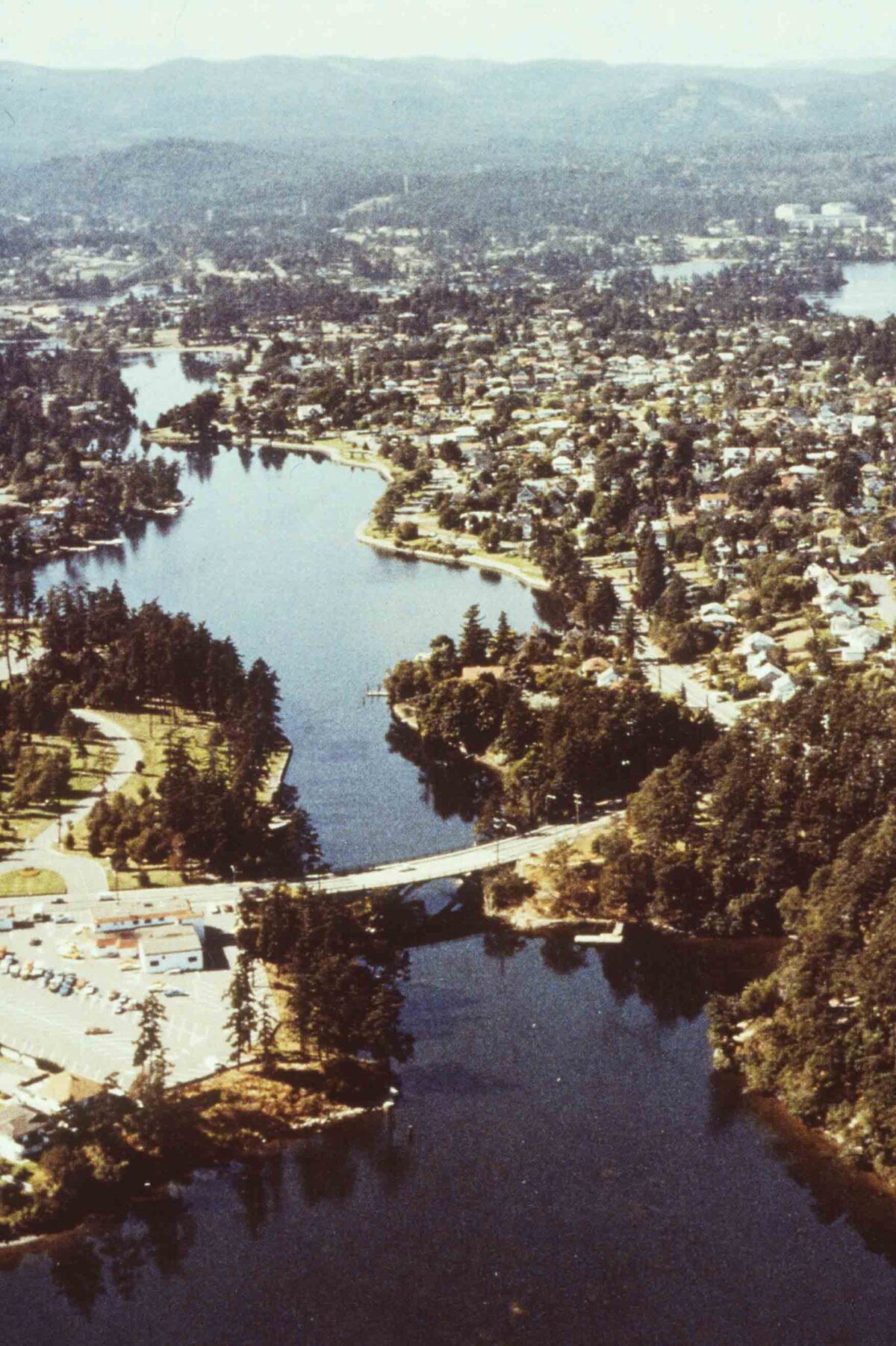
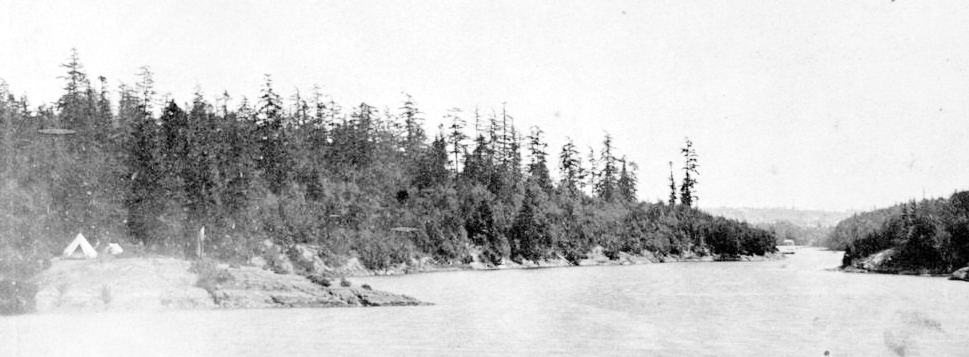
There are archaeological shellmiddens representing village sites that could have been occupied on a seasonal basis or for much of the year, on both sides of the Gorge Falls. The site on the south side is site DcRu-5, which I dated to 4120 years (SFU782). It is comparable in age to a site I dated on Fleming Beach DcRu-20, on the south shore of Esquimalt, to 4151 (RIDDL253) years before present. The latter is several meters above the present shoreline. The dating of these two sites indicates when sea level came back up to near the current sea levels from extreme lows going back another 4000 years.
The Gorge Kinsmen Park Archaeological Site DcRu-5
Cultural deposits in this shellmidden site, extend along the shoreline from east of Tillicum Road and west around Gorge Kinsmen Park to the outlet of the creek at the northwestern end of the site. I observed midden in tree pull-ups about 80 meters west from the Tillicum Bridge in the 1970s. At that time, I observed there was more discontinuous but shallow midden extending west until more concentrated cultural deposits could be seen near the south end of the bridge over the Creek. I also observed a small area of midden on the north side of the old creek mouth, which now seems to have been mostly removed with housing and road development.
DcRu-5, had an upper shell zone containing mostly native oyster shells which once grew profusely in the Gorge waterway. Next in quantity were the bend nose clams found in the local small mud bays and the bay mussels seen growing on the rocks a few steps away. Saltwater fish at the site are an indication as to how far the sea level advanced to this location. There may have been a short period of time before the sea level rose to extend above the falls at high tide.
The upper Gorge waterway may have been a fresh water stream during the early occupation of the South Gorge Bridge site – possibly this accounts for the sparse amount of shell in the lowest zone of the deposits. See Appendix 1, for my 1991 excavation report.


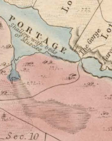
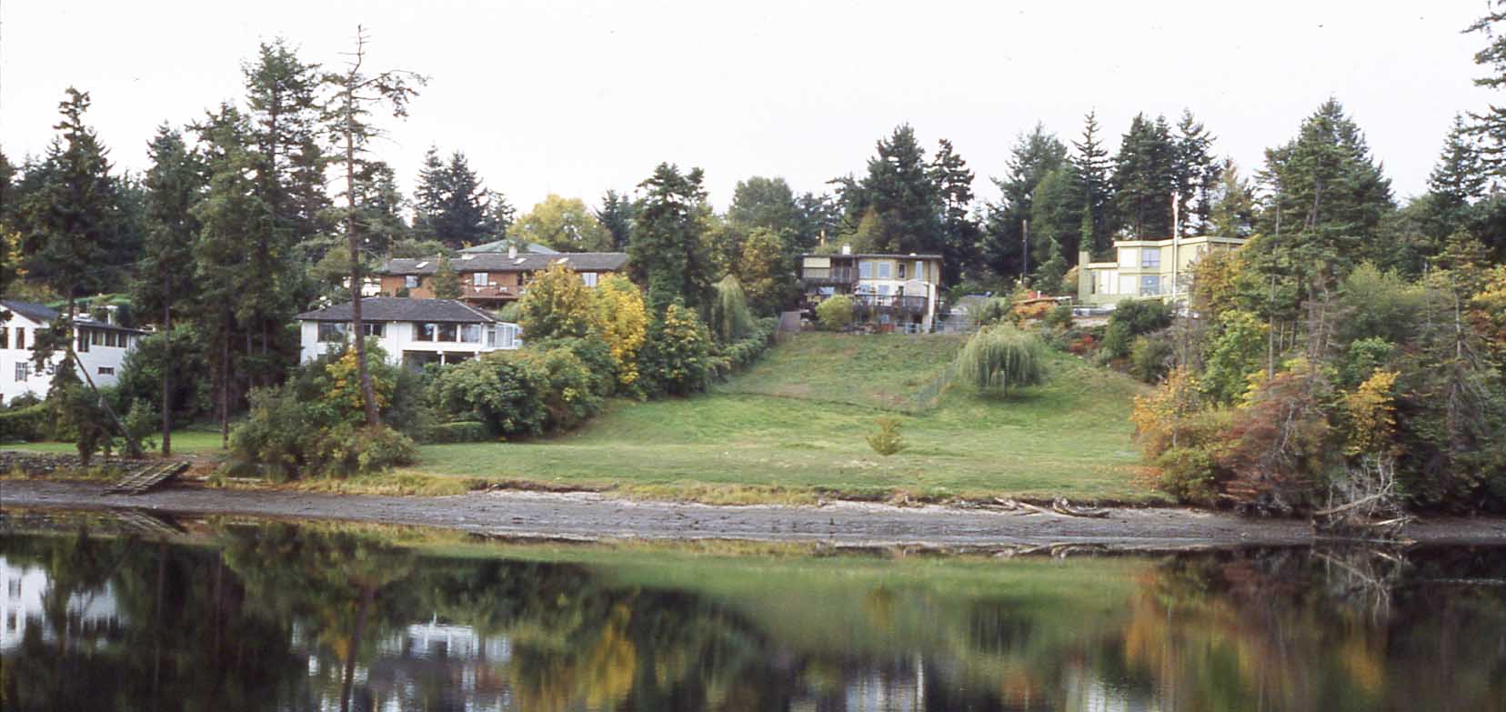
Figure 5, shows the west end of site DcRu-5, extending around the waterfront to the small bridge, on the far right. This bridge crossed an expanded inlet near the mouth of Gorge-Kinsmen Creek. The larger inlet, created as a swimming area, resulted from the building of a dam near the inlet entrance. Figure 6, shows the marsh area around the Creek as it looked on an1854 map.’
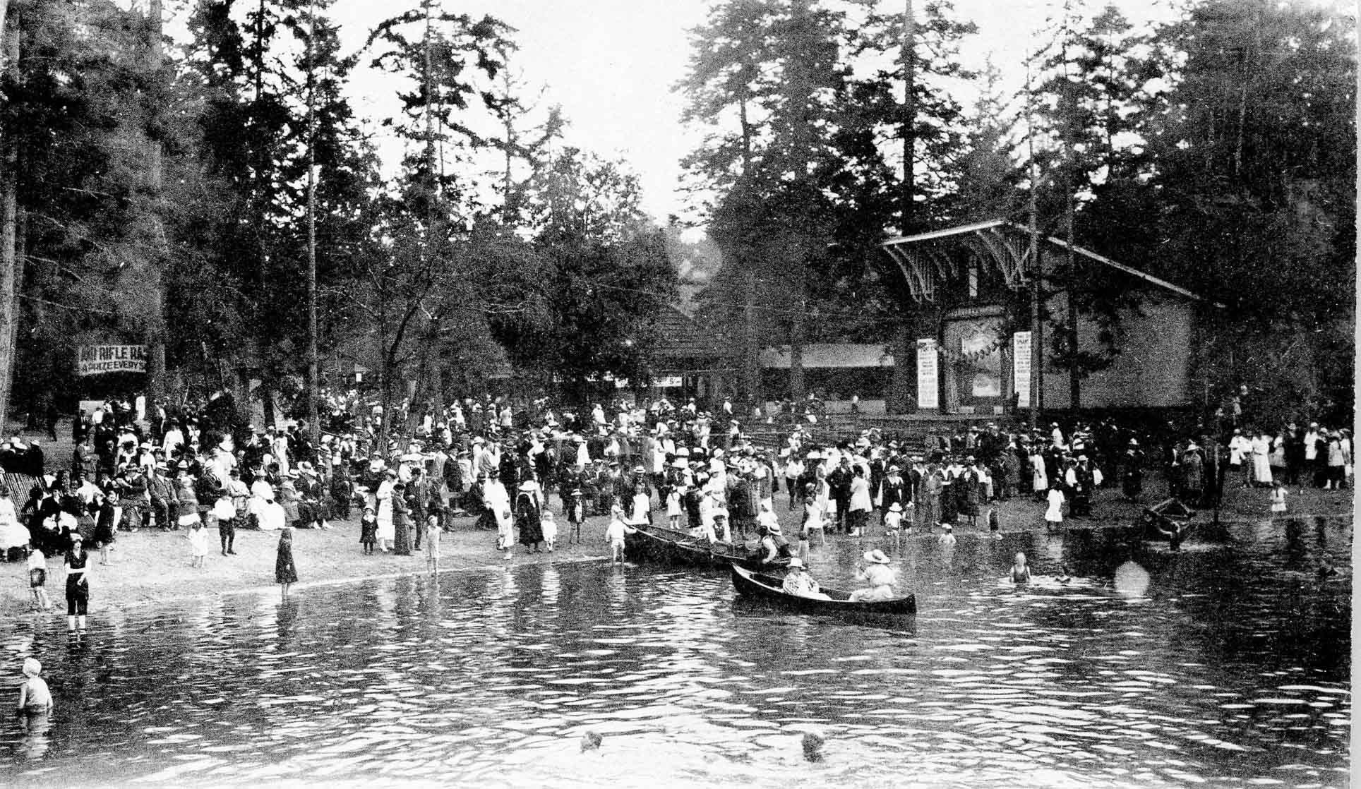
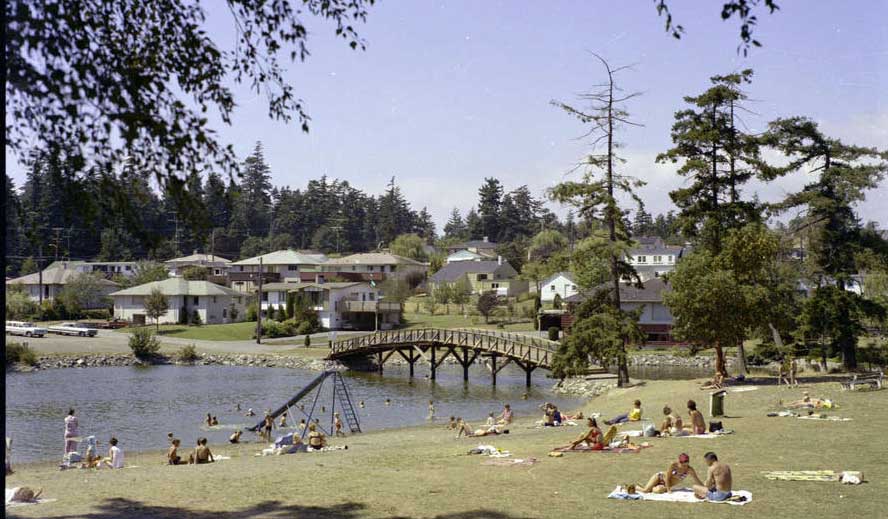
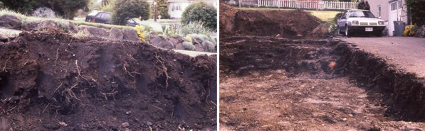
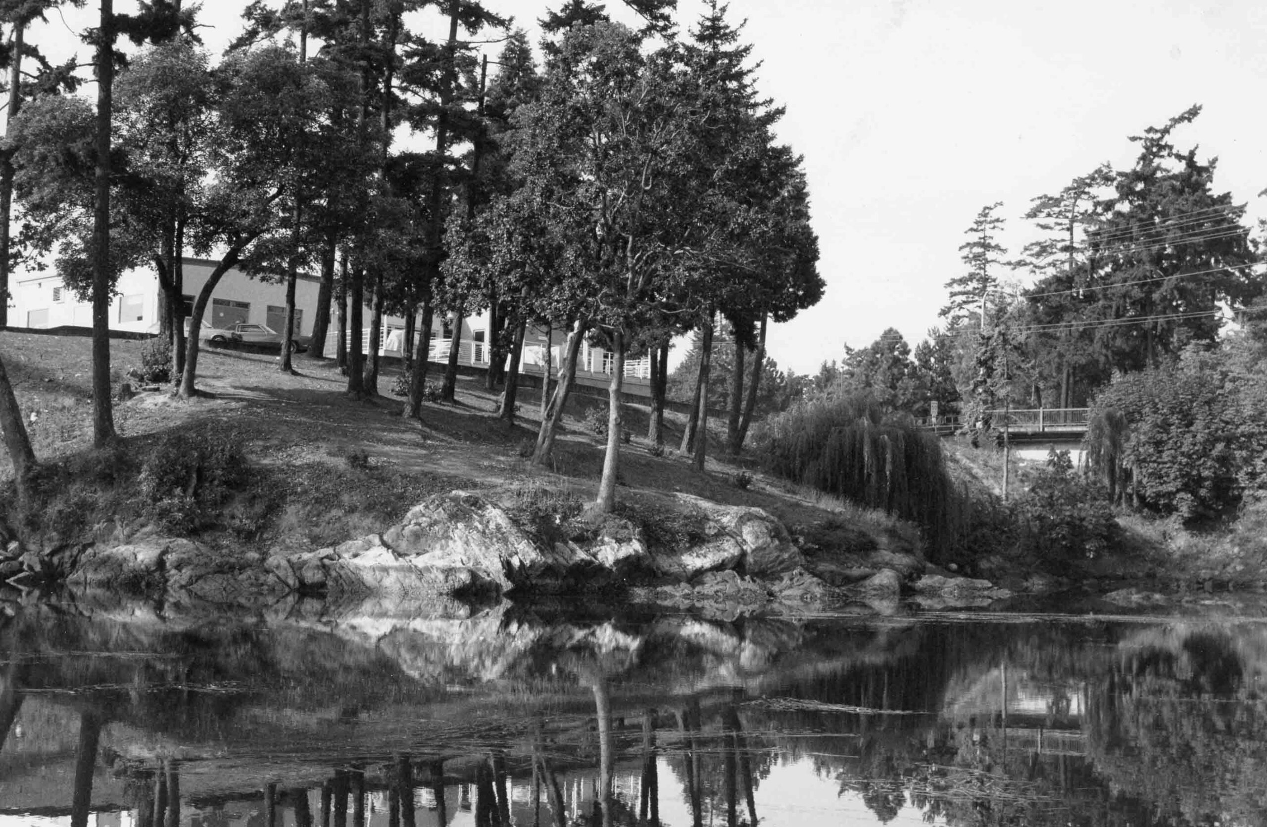
The landscape, especially at the west end of the site, was altered when it was part of the Japanese Tea Gardens after 1907 (Figure 7) and a popular swimming area in the 1970-80s (Figure 8). The creek has now been daylighted and the marsh area partially reconstructed. The area I observed with the most exposed midden in the 1970s to 1990s was the small mounded area near the S.W. corner of the inlet bridge. Midden was considerably disturbed when flattening out the area and installing a playground. There may still be some intact midden under the mounded area where the large trees are located.
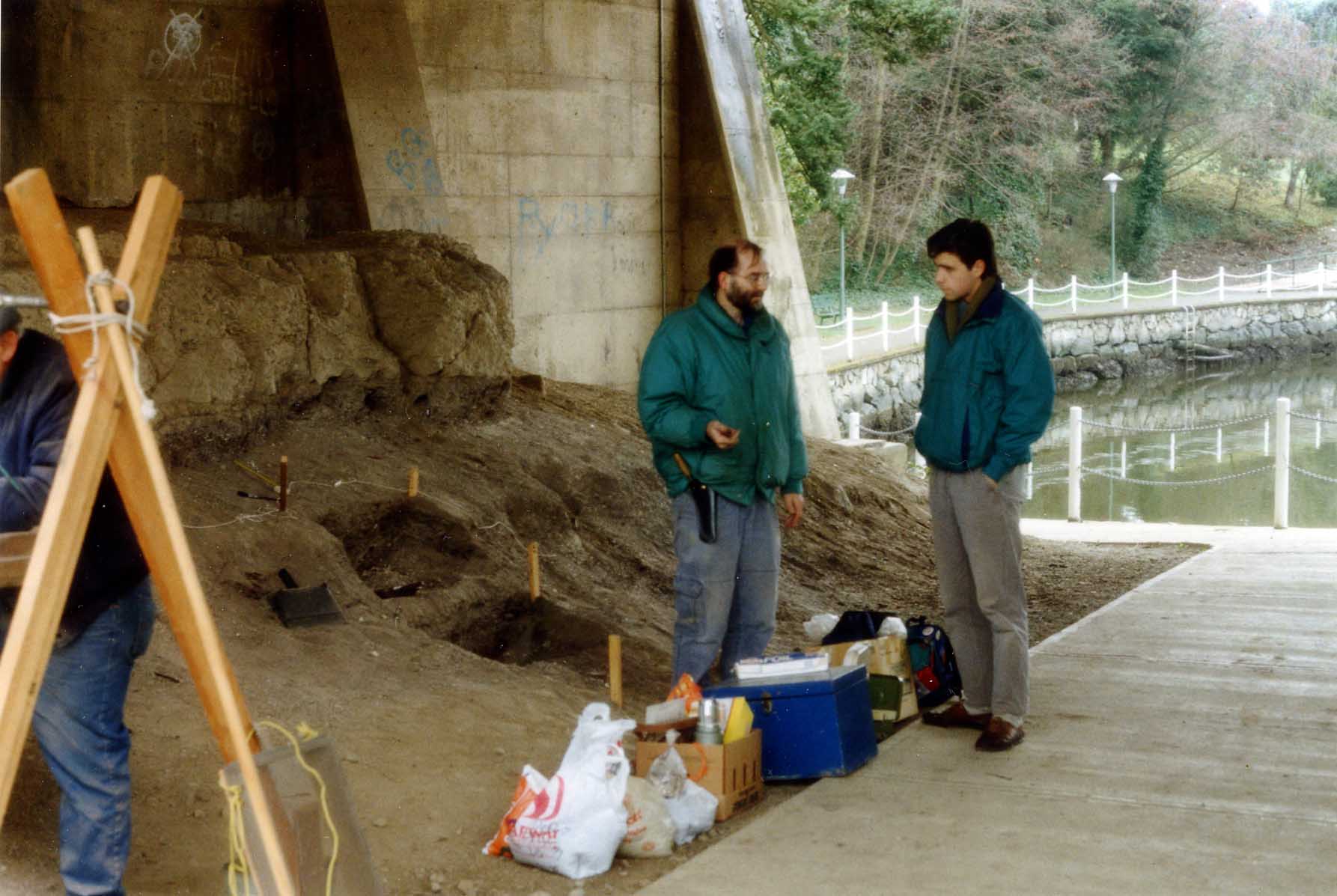
In 1991, I excavated, with volunteers from the Archaeological Society of B.C., the sites deepest cultural deposits, that were intact under the Tillicum Road bridge. See Appendix 1, for full report.
Figures 9 to 11, show the location of the excavation area under the Tillicum bridge. Figure 10, left, shows excavation Pit 2 at 140cm below the datum at its S.E. corner. Figure 11, on the right, shows the cement footings of a previous bridge, that crushed the upper cultural deposits, but protected older intact deposits further down. On the left is a steel wire cage built by the Esquimalt Parks Department to protect what remains of the in-situ cultural deposits.
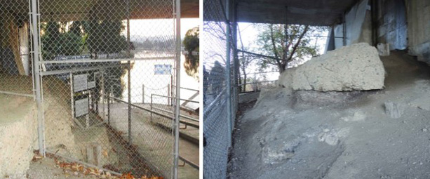
In 1991, I worked with Esquimalt Parks department in creating an exhibit in the caged area. This was vandalized by people who dug under the cage. Figure 11, shows a smaller second exhibit, that has now been removed. I proposed in 1991 that this would be a good location for an Indigenous mural on the back wall of the bridge. In the cage, we have the opportunity to work with the Lək̓ʷəŋən in creating a new outdoor educational exhibit. The area is now wheelchair accessible.
Site DcRu-7. North side of the Gorge Falls
This is a large shellmidden site that extends along the north shore of the Gorge from just east of Tillicum Road and west to Dysart Drive. The cultural deposits are deepest and most extensive in the 400-block area of Gorge Road.
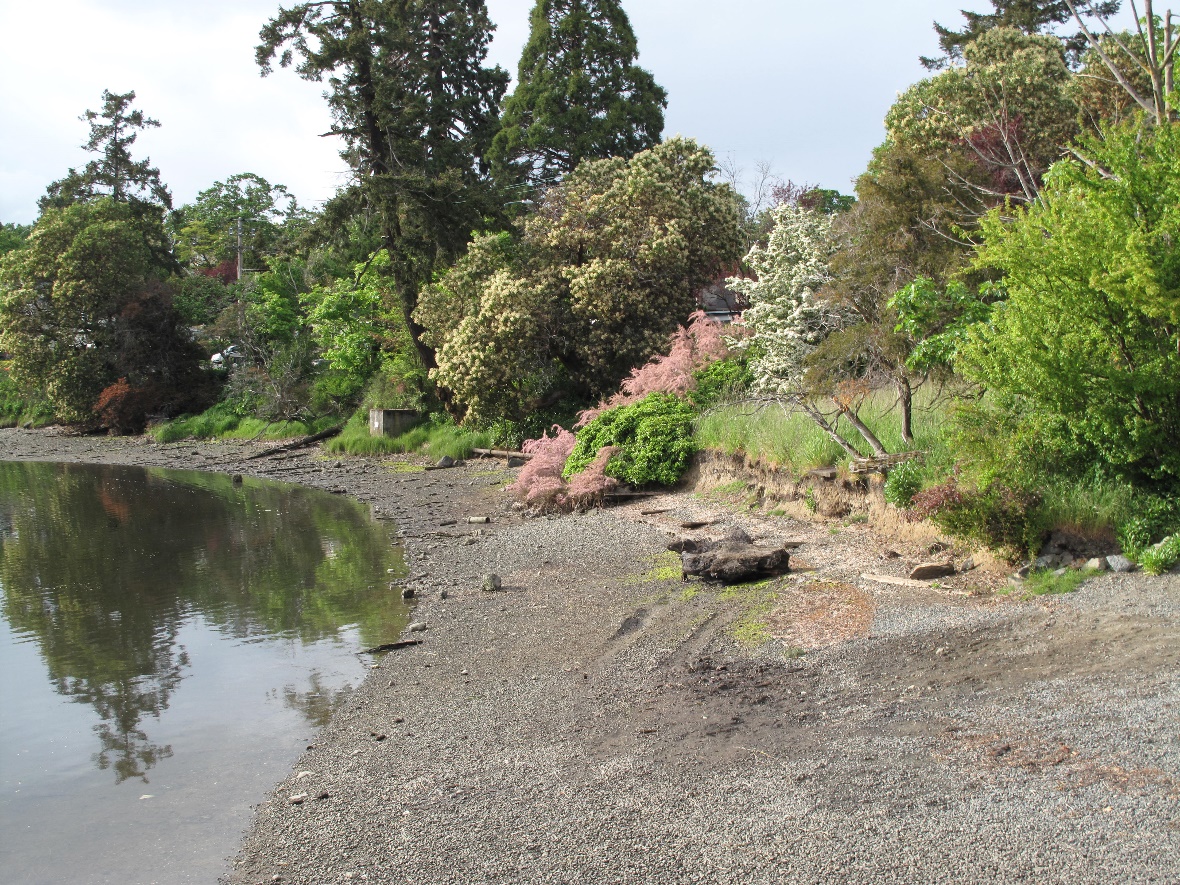

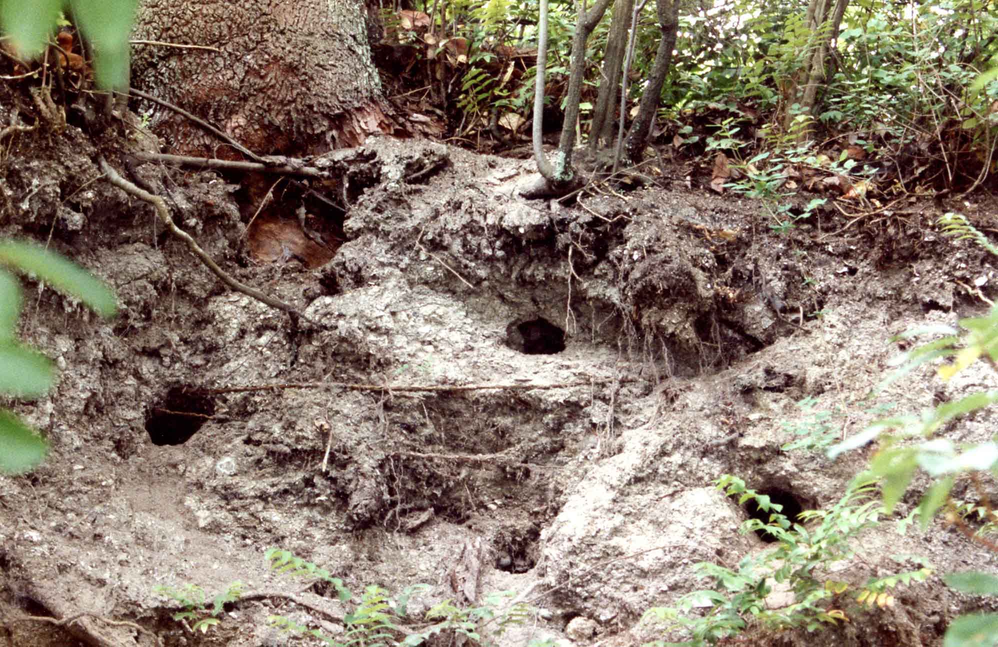
Figure 15, shows the shore of the old Gorge Retreat holiday resort. Many houses and cabins have been built and removed from this area over the years. In July of 1992, I observed otter dens dug into 150cm of shellmidden west of Tillicum Road (Figure 16).
It was in the 300-block area of Gorge Road where the midden extended furthest back from the Gorge shoreline. I observed the midden extending 26 meters north of Gorge Road on lot 11at 344 Gorge Road (figure 17).
For a detailed history of archaeological activities at this site, see my notes in Appendix 2.
Dating the Site
On October 23, 1989, while walking by, I observed a hole dug for a water pipe installation project, at the west end of the site on the north side of Gorge Road. It was near the S.W. corner of lot 7 at 482 Gorge Road on the municipal boulevard. This excavation project had failed to go through proper procedures regarding the known archaeological site in the area.
I took the opportunity to document the cultural deposits and extracted a 9.2gm charcoal sample, for radio-carbon dating, from the lower in-tact deposits. The location was 8 meters from the sidewalk and 36 meters from the Gorge waters. At this location there was a 1.2 m. exposure of cultural material above the hardpan clay (Figure 1). The upper 40 cm. to 50 cm was a disturbed mixture of shellmidden and noncultural soils. The lower portions were intact. These were composed mostly of charcoal stained, sandy soil with fire broken rock and scattered shell. One concentrated shell layer extended across the upper undisturbed deposits and two distinct 10 cm ash lenses occurred in the zone 10 cm. to 30 cm above the base of the cultural deposits.
The charcoal sample was extracted 20cm above the base adjacent to a 10cm ash lens. A radiocarbon determination of the sample was undertaken. The sample (SFU 786), produced an uncalibrated date of 1020+/-70 B.P. and a calibrated date of 950 B.P. with a range of 992 B.P. to 904 B.P. or 1000 A.D. with a range of 958 A.D. to 1046 A.D. for this portion of the site.
Notes on Images of Site Destruction
An enormous disturbance of this site occurred in July of 1972, when the municipality of Saanich dug up large quantities of shell midden along the Gorge seawall from Dysart to Gorge View streets for the construction of a sidewalk and sea wall.
Provincial Museum staff, Don Abbott, Kevin Neary and Phil Muron, visited the location on August 1, collecting artifacts from the large piles of bulldozed midden and areas levelled for the sidewalk. Don Abbott took slide photographs that were all very under exposed and unlabelled. I have computer enhanced his attached images. Most are taken across from 482-492 Gorge Road near Parkview.
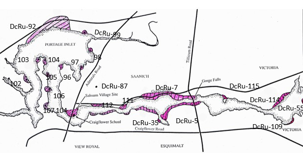
The Arran Point Site DcRu-115
Arran Point was once called Curtis Point. It is a rocky protrusion into the Gorge waters on the north side, east of the Gorge Falls. Little is known about this site.
This shellmidden site has been heavily disturbed with the development of apartments behind it. During the late 19 and early 20 centuries the site area was used extensively for camping (Figure 23) and was excessively trampled during boat regattas and swimming events (Figure 24).
In 1975, when first recorded, the site was determined to be 50 meters long by 6 meters wide and 40cm deep. It extended alone the back of Aaran Point. I observed midden buried in the embankment at the N.W. back of the Aaran peninsula in a treed area, where I found a slate point protruding from the cut bank. Nearby I found a small core fragment. It is possible there is a remnant of intact cultural deposits left in this area.

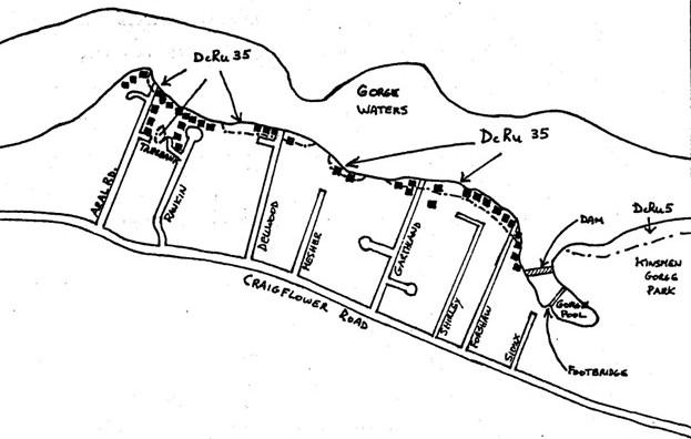
Archaeological Site DcRt-35.
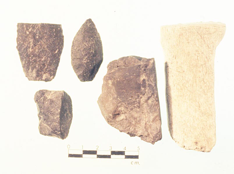
This site has been recorded intermittently over the years, and has never been well defined. It was originally recorded as being about 1125m by 30m in dimension and varying from 10cm to 80cm in depth. It stretches from the south side of the Gorge Inlet near the old dam and west along the shoreline to the end of Aral Road. The site area has been heavily impacted by housing development. It may have been nearly continuous at one time but occupied sporadically at different time periods. Figure 25, shows the discontinuous nature of the identified shellmidden. There were many artifacts collected by private individuals in the past but very few ended up in museum collects. See figure 26 for the few examples.
Archaeological Site DcRu-112.
This is a small shellmidden recorded on the shore at the end of Inez Drive in 1975. It was recorded as being 63 by 27 meters and 20cm deep. In 1979 no evidence of it could be found, and I could not find any evidence during the road and sewer construction of 2023-24.
The Recorded Lək̓ʷəŋən History
The historic period from the 1780s to the mid 1800s brought enormous changes to Indigenous populations in the greater Victoria region and beyond. This first occurred before the local settlement of Europeans, with population displacements due to inter-tribal warfare and the westward movement of diseases. Further changes came with the establishment of Hudson’s Bay Company Forts, more diseases and the intensification of European related economic activities. This, and the piecemeal and late recording of local Indigenous stories, has resulted in much confusion in local Indigenous history.
At the time of the founding of Fort Victoria the local Lək̓ʷəŋən had villages in locations from Cordova Bay to the Albert Head area. During the creation of the treaties with the Lək̓ʷəŋən in 1850, James Douglas divided up the land according to different family groups as could be identified at the time. In the treaties an extended family called the Kosampson (Xwsepsum) were assigned the territory which included most of Esquimalt peninsula, the Portage inlet, Colquitz creek and the Gorge above and including Halkett Island. It was the descendants of some of this family that first settled on the Esquimalt Reserve on the east side of Esquimalt harbour.
According to James Deans, who in the later 19th century, talked to Indigenous elders about their history, the Esquimalt people formerly lived on the Gorge at the site of the old Craigflower school house where “they moved in not very remote times” (Deans 1898). This is the location of an Archaeological site DcRu-4, that will be discussed in Part 3.
Another family called the Swengwhung were assigned a piece of western Victoria which included the inner harbour and around the James Bay Community shoreline to Ross Bay. Later discussions with Lək̓ʷəŋən elders in the late 19th century to the 1950’s provided conflicting claims about which family groups traditionally used the southern part of the Gorge.
Wilson Duff, an anthropologist at the (then) British Columbia Provincial Museum, obtained information from Songhees band members Jimmy Fraser in 1950 and Sophie Misheal and Ned Williams in 1960. According to their information, the property of the old Craigflower school house was called “Skosappson”, the same name as the “Kosampson” of the 1850 treaty. Edward Joe, a descendant of the “Kosampson” of the 1850 treaty – now anglicized as Xwsepsum, said this was the former village of his people. He was the grandson of Sisinuk, a signer of the treaty.
The written documentation on the western part of the Gorge is sketchy and contradictory. Members of the Xwsepsum argued that the Swengwhung were a new group of people from various outside villages who settled in the Gorge only after the founding of Fort Victoria.
In speaking of the different amalgamated groups who lived on the old Songhees reserve in Victoria harbour after the founding of Fort Victoria, Bishop Lemmens states in 1893 that: “the present population across the harbour is made up of four different little tribes, only one of which originally belongs to Victoria … the Skween-ghong alone originally lived on Victoria Harbour, … am assured that there are only four or five men left of the original Victoria tribe, the Skween-ghong. I got this information from Mrs. Falardeau, who is a reliable woman and who knows all about it, for she remembers the time when these Indians moved to Victoria harbour. She declared to me positively that these are the facts, and I am confident that she tells the truth. I heard the same thing today from other Indians, who told me about it unasked.”
In the 1950’s and 60’s some Songhees band elders said that Swengwhung was the name of the people who formerly lived on the upper part of the Gorge above the bridge. Jimmy Fraser said that the name of the people inside the Gorge was a Songhees name but that it referred to the name of the language rather than the people. Fraser said these people died out from some sickness and were now all gone “except one old Duncan women whose mother belonged” to these people. Ned Williams “had heard that their houses had been on the little bay at Gorge Park”. This would be the west end of the Archaeological site DcRu-5.
In 1950, Fraser and Williams indicated to Anthropologist Wilson Duff that there were two villages on the north side of the Gorge. One was located at the point between Adelaide and Austin avenues. This would be part of archaeological site DcRu-111. There is almost no midden at this location which would indicate the site had very limited occupation. The other was at the end of Inez Street at the central western end of the shellmidden site DcRu-7.
Fraser (born in 1871) never saw houses there but Ned Williams (born 1885-90) “had heard that their houses had been on the little bay at Gorge Park”. Duff’s sketch map drawn during a visit to the Gorge with Jimmy Fraser show X’s marked “where three villages of Indians lived …most at lower 2 – a few at school house”. One is the Craigflower school site, DcRu-4, and the others are on the north side of the Gorge at the point between Adelaide and Austin avenues (now recorded as Archaeological site DcRu-111) and one at the end of Inez Street at the west end of a shellmidden site (DcRu7) which extends along the Gorge to the park on the east side of the Tillicum bridge.
In his notes Wilson Duff indicates that: “1st village is on point between Inez and Parkview St. at least 2-3′ of shell deposits here. (oyster, mussel). 2nd at point where road divides 719 Gorge, just past Oscar St. [Duff meant Austin street, not Oscar] is right on site. No shell faces, but showings of shell.” (Duff Notes, Jan. 10, 1950).
In 1934-35, Diamond Jenness of the National Museum of Canada interviewed local Indigenous people including Jimmy Fraser (age 70) and Mr. and Mrs. David Latess of Brentwood Bay. David Latess was 85 at the time. Before joining the Saanich band at Brentwood Bay David Latess was a Songhees on his father’s side. Several of his uncles were buried on the Old Songhees reserve. Jenness stated that: “The old summer home of the Songhees was at Xthapsim, just above the Gorge at Victoria; their winter home at Cadborough bay” (Jenness, 1934:43). In another context Jenness mentions that: “It was through fear of both the Comox and the Kwakuitl that the Songish retreated in summer above the Gorge at Victoria,” (Jenness n.d., p. 1).
References
Dahlstrom Bruce. 1998. (I. R. Wilson Consultants Ltd). Archaeological Impact Assessment and Report on Construction Monitoring Victoria Kayak and Canoe Club 355 Gorge Road West, Victoria, B.C. Heritage Conservation Act Permits 1998-135 and 1998-238.
Deans, James. 1898 Quoted in the Minutes of the Natural History Society of British Columbia for July 1, vol. 1, p.58. (Archives of B.C. Additional Manuscript 1077).
Douglas, James. 1843. Diary of a trip to Victoria, March 1-21, 1843. Provincial Archives of British Columbia (A/B/40/D75.4a).
Foster, Harold D. 1972. Geomorphology and water resource management: Portage Inlet, a case study on Vancouver Island; Canadian Geographer, v. 16, pp. 128-143.
Golder Associates Ltd 2016. Gorge Road West, Wyndeatt Avenue Utility Upgrade Project – Archaeological Monitoring, Saanich, BCHCA ALTERATION PERMITS 2013-0027, AND 2016-0027.
Golder Associates. 2012. Archaeological Impact Assessment, 311 and 313 Gorge Road West, Saanich, BC. Report on file with the Archaeology Branch, Ministry of Forests, Lands and Natural Resource Operations, Victoria, BC.
Golder Associates. 2010. Archaeological Impact Assessment, of Four Sewage Lift Stations, Saanich, BC. HCA PERMIT NO. 2010-0084. Report on file with the Archaeology Branch, Ministry of Forests, Lands and Natural Resource Operations, Victoria, BC.
Golder Associates 2006 Archaeological Monitoring of Park Expansion Developments at Site DcRu-7, Saanich, BC. Site Alteration Permit 2000-338. Report on file with the Archaeology Branch, Ministry of Forests, Lands and Natural Resource Operations, Victoria, BC.
Golder Associates Ltd. 2002. Archaeological Investigations at DcRu-7, A shellmidden site in Saanich, B.C. Heritage Investigations Permit2001-119. On file with the Archaeology and Registry Services Branch. Victoria.
Golder Associates Ltd. 2000. Archaeological Impact Assessment of Proposed Park Expansion Developments, Gorge Waterway Park, Saanich, B.C. Heritage Inspection Permi 2000-245. Report on file with the Archaeology and Registry Services Branch, Victoria, B.C.
Golder Associates Ltd. 2000b. Report on Archaeological Monitoring of Park Expansion Developments at Site DcRu-7, Saanich B.C. Site Alteration Permit 2000-338.
Keddie, Grant Ross. 1990a. Archaeological site record for DcRu7. Archaeology Branch, Ministry of Small Business, Tourism and Culture, Victoria.
Keddie, Grant Ross. 1990b. Notes on Archaeological Activities at the North Gorge Bridge Site, DcRu-7. Attachment to site form for DcRu-7, on file with the Archaeology Branch, Ministry of Small Business, Tourism and Culture, Victoria.
Keddie, Grant. 1991. Spirit Divers and Spirited Diggers. The Midden, Publication of the Archaeological Society of British Columbia, Vo. 23, No.3, pp. Cover, 6-7.
Keddie, Grant. 2013. Victoria’s Chinese Immigrant Fishermen in Victoria Harbour. Royal B.C. Museum Web Site.
Keddie, Grant. 2025. Camossung. Bridging two Worlds. January 6, 2025. GrantKeddie WordPress.
Lambert, Philip. 1967. The Biology and Distribution of Ostrea lurida and Crassostrea gigas in Portage Inlet. Zoology 449 Thesis submitted in partial fulfilment of the requirements for the degree of B.Sc. in Zoology, University of Victoria.
Lemmens, J. N. 1873. Letter of March 28th, 1873 of J. N. Lemmens, Bishop of Vancouver Island. RBCM Archives, RG10, vol. 1343, reel B1874.
Wilson, Captain Charles. 1866. Report on the Indians Inhabiting, the Country in the Vicinity of the Forty-nineth Parallel of Northern Latitude. Translations of the Ethnological Society of London. New Series. Vol. 4:275-332.
Appendix 1.
Gorge Falls Archaeological Site DcRu-5.
THE GORGE FALLS LOOKOUT.
ARCHAEOLOGICAL SITE, DcRu 5.
MONITORING the CONSTRUCTION of a HANDICAPPED ACCESS ROUTE.
REPORT TO THE ARCHAEOLOGY BRANCH
IMPACT ASSESSMENT PERMIT 1991-17
BY GRANT KEDDIE, ROYAL B.C. MUSEUM
INDEX
MANAGEMENT SUMMARY P. 2
INTRODUCTION P. 2
HISTORICAL BACKGROUND P. 6
PROJECT AREA P. 6
CONSTRUCTION PROJECT P. 7
THE TEST EXCAVATIONS P. 8
EXCAVATION OF TEST PIT 3 P. 13
RESEARCH DISCUSSION P. 15
RESULTS P. 16
ACKNOWLEGEMENTS P. 17
BIBLIOGRAPHY P. 17
APPENDIX 1 P. 18
APPENDIX 2 P. 19
APPENDIX 3 P. 20
FIGURES
1 MAP DRAWING OF PROJECT AREA P. 3
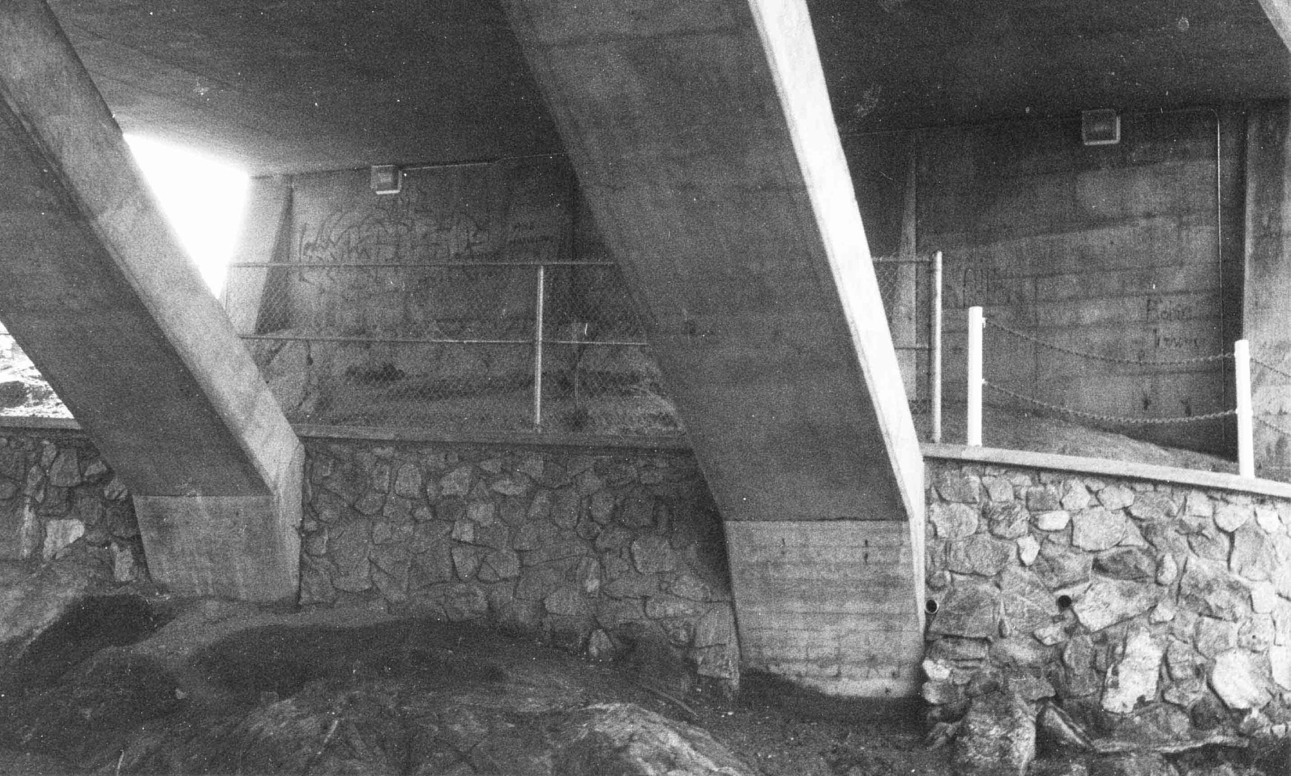
2 PHOTO OF GORGE FALLS AREA P. 4
3 PHOTO OF SITE AREA EAST OF BRIDGE P. 5
4 PHOTO OF MIDDEN LOCATION P. 8
5 DRAWING OF MIDDEN AND TEST PITS P. 9
6 PHOTO OF MIDDEN AND EXCAVATION AREAS P. 11
7 PHOTO OF TEST PIT 2 STRATIGRAPHY P. 12
8 DRAWING OF TEST PIT 3 STRATIGRAPHY P. 14
MANAGEMENT SUMMARY
This project involved the monitoring of a Municipality of Esquimalt sidewalk installation across a portion of site DcRu 5, under the Tillicum road bridge on the Gorge waterway. Test excavations in deposits which date back over 4100 years ago, resulted in the recovery of mollusc remains and a small bone and artifact sample from two distinct matrix zones. Design plans were changed to minimize site impact and intact midden locations were identified and protected in a steel link fence.
INTRODUCTION
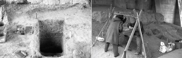
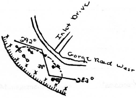
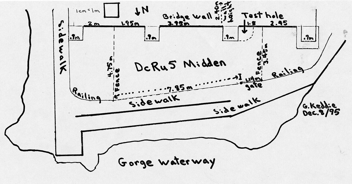
In August of 1990, both myself and Tom Bown of the Archaeological Society had discussions with Gladys Durrant of the Esquimalt Heritage Advisory Committee in regard to the matter of a conflict between a newly proposed handicapped access walkway around the east side and under the Tillicum Road bridge and a portion of the prehistoric shellmidden DcRu-5 (Figure 1). Mrs. Durrant brought the matter to the attention of the Heritage Advisory Committee, the Municipal council and the appropriate Municipal directors.
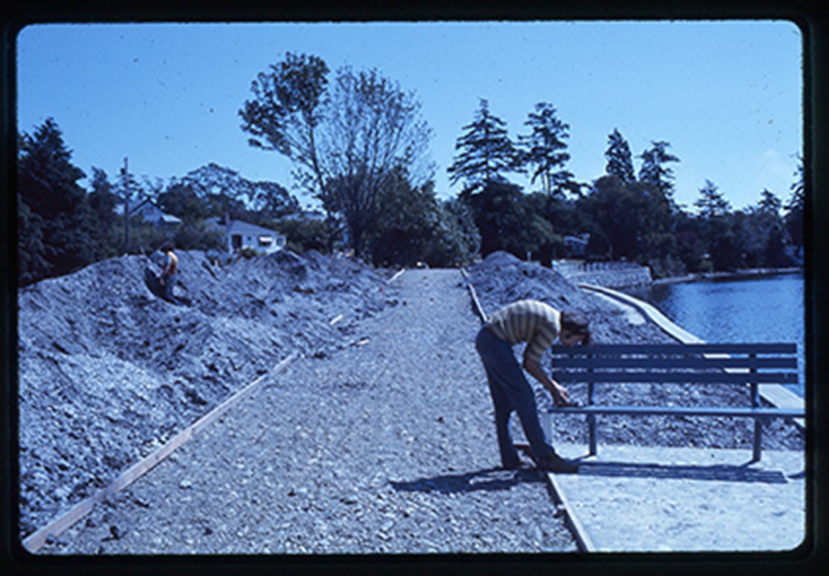
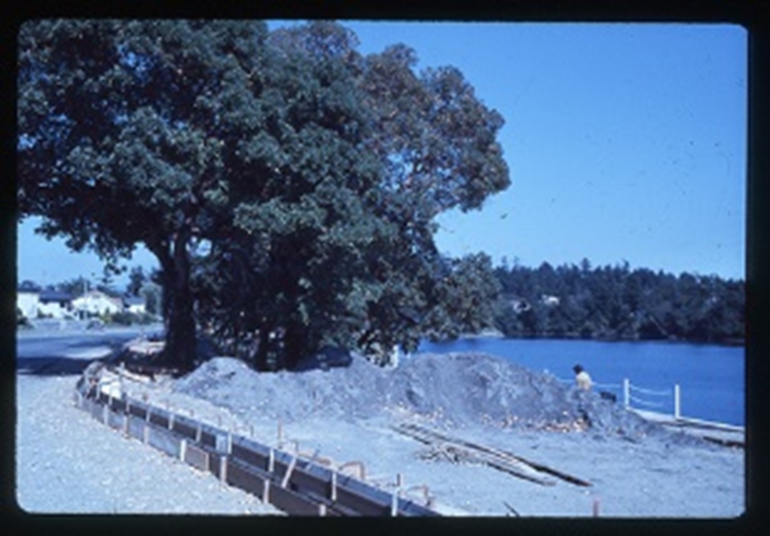
I visited Richard Nordlund, Director, Planning and Engineering Services for the Municipality of Esquimalt and as a follow-up was sent a map of the proposed walkway, dated October 19, 1990. After correspondence on the subject I was contacted on Feb.21, 1991 by Norman Pugh, Deputy Director, Planning and Engineering Services and met Mr. Pugh and Bob Seright of the Heritage Advisory committee at the project location to examine the shellmidden deposits adjacent to the cement bridge footings. Mr. Pugh had the walkway plans re-drawn to minimize damage to the site. The new plans involved bringing the walkway straight down the East side of the peninsula to the existing lookout walkway instead of cutting across the midden at an angle from the corner of the bridge abutment wall (Figure 2 and 3).
After a letter of Feb. 18, 1991 to Jack Bouttillier, Director, Parks and Recreation Services I was invited to give a presentation to the Esquimalt Parks and Recreation Committee. After the presentation the Committee passed a motion recommending that the Esquimalt council ensure protection for the portion of the site under the bridge.
I applied for a permit and undertook the test excavations and monitoring of the construction work during the month of March.
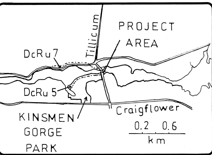
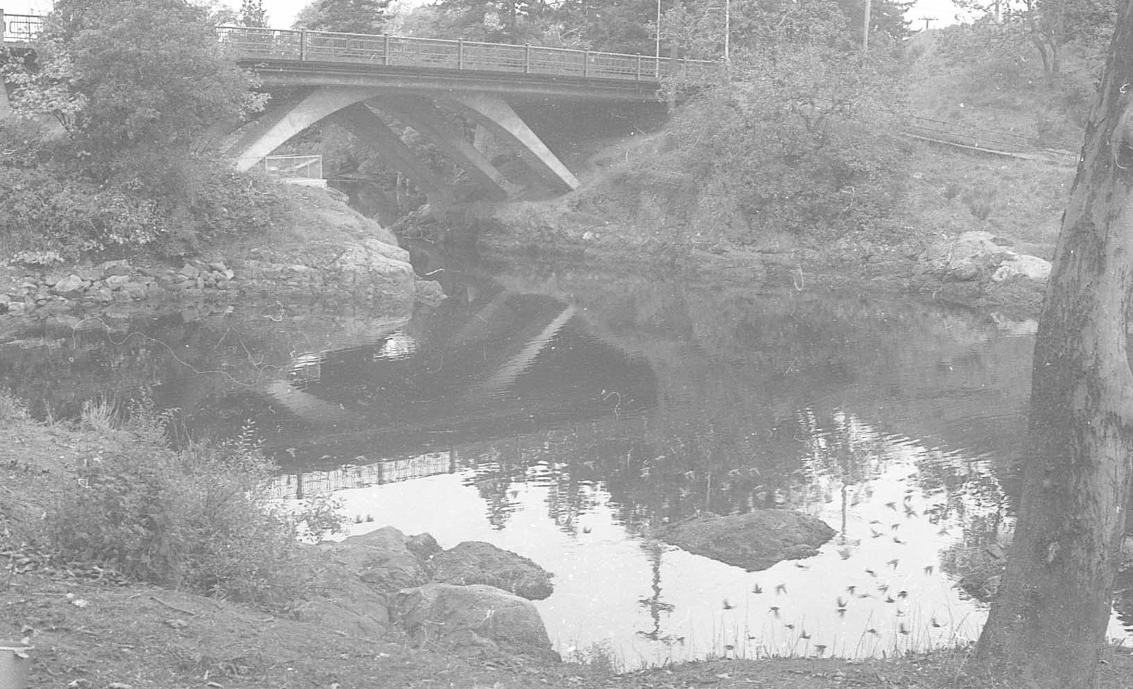
Figure 3, shows where the East end of DcRu-5 extends to area at centre of photo. The midden in this whole area east of the Tillicum bridge has been seriously disturbed and only shallow traces of it remain. The new sidewalk extended from the Gorge Hotel parking lot along the wall of the Tillicum bridge a the right This area is just south of that shown in Figure 2.
HISTORICAL BACKGROUND
The shellmidden site DcRu 5, was first officially recorded in 1959 by Robert Kidd. It was later updated in 1975 by Steve Acheson and Calvin Claxton (Tsawout (SȾÁ,UTW̱) and again in 1979 by Bob Powell, Mary Woodley and Marvin James (Lək̓ʷəŋən). I have visited the site many times over the last 17 years and have observed minor disturbances by parks activities and up-rooted trees. The site originally extended from just east of the Tillicum bridge along the shoreline to the knoll at the North end of the present footbridge.
Much of the open play area to the west of the Kinsmen concession booth was a bay that has been filled in. Much of this fill is midden that has been scrapped from along the shore in this area. This bay can be seen in the 1928 air photograph. The small knoll at the north end of the present foot bridge contains shallow (under 0.10m) midden deposits which may be partially intact in some areas. These deposits are probably the base of what was once a deeper midden. Artifacts that I have surface collected in the past have come from this locality (see R.B.C.M records). Sidewalk development has disturbed many parts of the site along the waterfront to the Tillicum bridge. Most of the site in the immediate area of the Tillicum road bridge has been destroyed by road, bridge and other construction activities.
In 1988, I observed exposed midden under the Tillicum bridge extending out to the north of the bridge wall under a large cement pad footing that was part of the support for an earlier bridge. The upper most deposits were disturbed but the lower deposits were in-tact. I extracted a sample from a dark layer below an upper layer of concentrated shellfish remains. At the time I thought this may be near the bottom of the cultural deposits, but it later proved to be the top of a much deeper zone. The radio carbon estimate for the sample was 4120 years ago (3750-+80, S.F.U. 782 -corrected after M. Stuiver and P. J. Reimer, Radiocarbon, 28, 1022-1030, 1986).
PROJECT AREA
The project area is on the south side of the Gorge Falls on a rocky peninsula under the Tillicum road bridge. Based on the observation of photographs spanning the period from the 1860s to the 1930s the land surface originally rose gradually upslope from the high water mark for several meters in elevation. The shellmidden is roughly about 1.5 to 3 meters above high tide level. A small bay extends immediately to the east of the location, and on the west or upstream side, the Gorge waters widen out to the South. The deeper waters of the Gorge vary from about 1 to 3.1 meters at low tide. The area below the falls on the east side is one of the deepest at 3.1 meters.
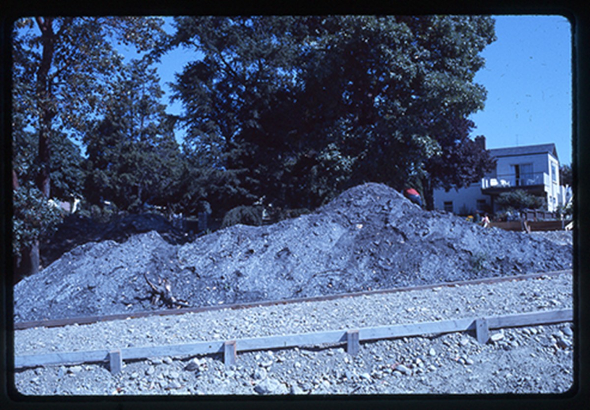
The midden under the bridge appears to be the only intact midden left in the general area of the Tillicum bridge. The original area of the upper zone of the midden was about 21m by 5m and the lower zone about 21 m by 6m. Part of the upper zone has been removed from the north end along the water by construction of the first “lookout walkway” and activities related to early bridge building (Figure 4).
CONSTRUCTION PROJECT
A 1.7m handicapped access walkway was to be constructed above the existing ground level under the Tillicum bridge along the existing “lookout walkway”.
Along this 16m west to east axis of the proposed walkway there was a possible conflict with a 5m section of midden that was higher than the ground surface to the north. Small trowel holes demonstrated that the surface deposits just below the raised area and the existing sidewalk were disturbed and therefore would not be impacted by the sidewalk construction. In order to determine exactly where the intact midden deposits started a Test Pit #1 was excavated at the edge of the proposed sidewalk (Figure 5).
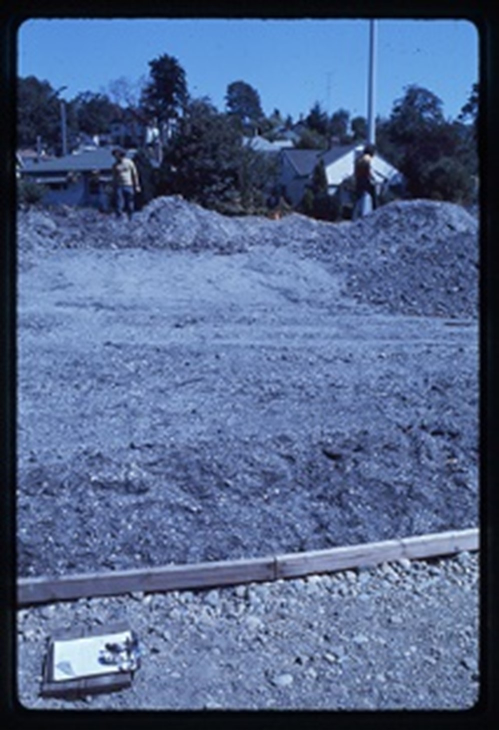
The longest part of the new walkway was an extension from the E. end of the Lookout walkway along the East side of the Bridge. The backhoes were to dig this area down considerably (up to 1.5m) but shovel testing revealed that most of this area was composed of rubble rock and soil fill with disturbed midden observed only near the N.E. corner of the bridge abutment. It was expected that if there was intact midden it would be impacted by the excavations only in a small 3m area buried under fill below the edge of the slope to the East of the existing visible midden. It was decided to monitor and test this area during the construction project.
THE TEST EXCAVATIONS
Excavation was undertaken by myself and volunteers from the Victoria Branch of the Archaeological Society of B.C. We set up the screens for taking a total faunal sample and began excavation of Test Pit #1 within the bounds of the proposed sidewalk. The Pit was located 8.8m W. of the east end of the existing lookout walkway and 1.06m S. of it. This 1 meter pit was 1.12m N. of the cement slab above the midden. After excavating several 5cm layers it became clear that this pit was extensively disturbed. The southern 20 cm of the pit contained shellmidden with some disturbance but the rest of the pit contained fragments of recent (last 30 years) glass bottles, plastic, round headed nails, cement re-enforcing rods, copper wire, cement chunks and brick pipe fragments.
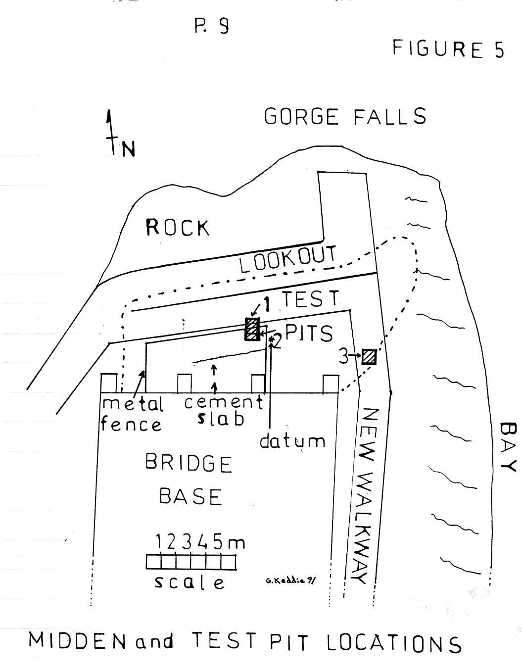
Pit 1 was abandoned and Test excavation Pit #2 was then extended .50m to the south or .62m from the cement slab (Figure 6). The cut midden at this point extended up slope. The S.E. corner of the pit being .43m below the datum as opposed to .82 below the datum for Pit 1. The datum used is a nail in a cement support 1.20m east of the N.E. corner of Pit #2 and in line with the S. wall of this pit. This datum is 1.3m above the “Lookout walkway”. Pit #2 is 3.6m N. from the modern cement bridge wall and 2.06m (from its N. wall) to the original or first cement Lookout walkway. The walkway along the west side of the peninsula is 8m west of Pit #2. The East side of Pit #2 is North from the centre of the 2nd (from the East) cement bridge base extension on the present bridge.
The upper shell zone of Pit #2, designated Zone A, was excavated in .10m levels and extended to .70m below the surface (Figure 7). Scattered fire broken rocks occur throughout the deposits. The colour of the silty humic, charcoal stained soil varied from 5YR 5/1 to 5YR 2.5/1. The Zone contained small patches of concentrated and burnt shells.
The faunal remains in this Zone are mostly shells from native oyster which once grew profusely in the Gorge waterway. Next in quantity were the bay mussels, seen today growing on the rocks a few meters away, in smaller quantities are native little neck clams and, occurring in about the same frequency, the bent nose clams found in the local small mud bays. Very small numbers of cockle clams and butter clams occur. Only a few barnacle and whelk fragments were found that could be from edible size specimens. Limpets found were also too small to have been food remains. Small periwinkles, limpets and barnacles were probably brought to the site attached to eel grass, kelp, crabs, clams or rocks. Appendix 2 includes the proportions of the various shell and other shoreline resource remains from level 1 of Test Pit #2. The shell from the other 13 levels remains to be analysed.
Only a small faunal bone sample was recovered. This included mostly fish bones: The majority are herring and dog fish with surf perch, salmon and other smaller fish remains present. Other remains include bird bones; crab claws; and mammal bone fragments which include deer and seal. Appendix 1 show the screen collected samples from all the levels of test Pit #2. Level 1 also includes the bones found in the processed matrix samples. The other level matrix samples have not been searched for bone.
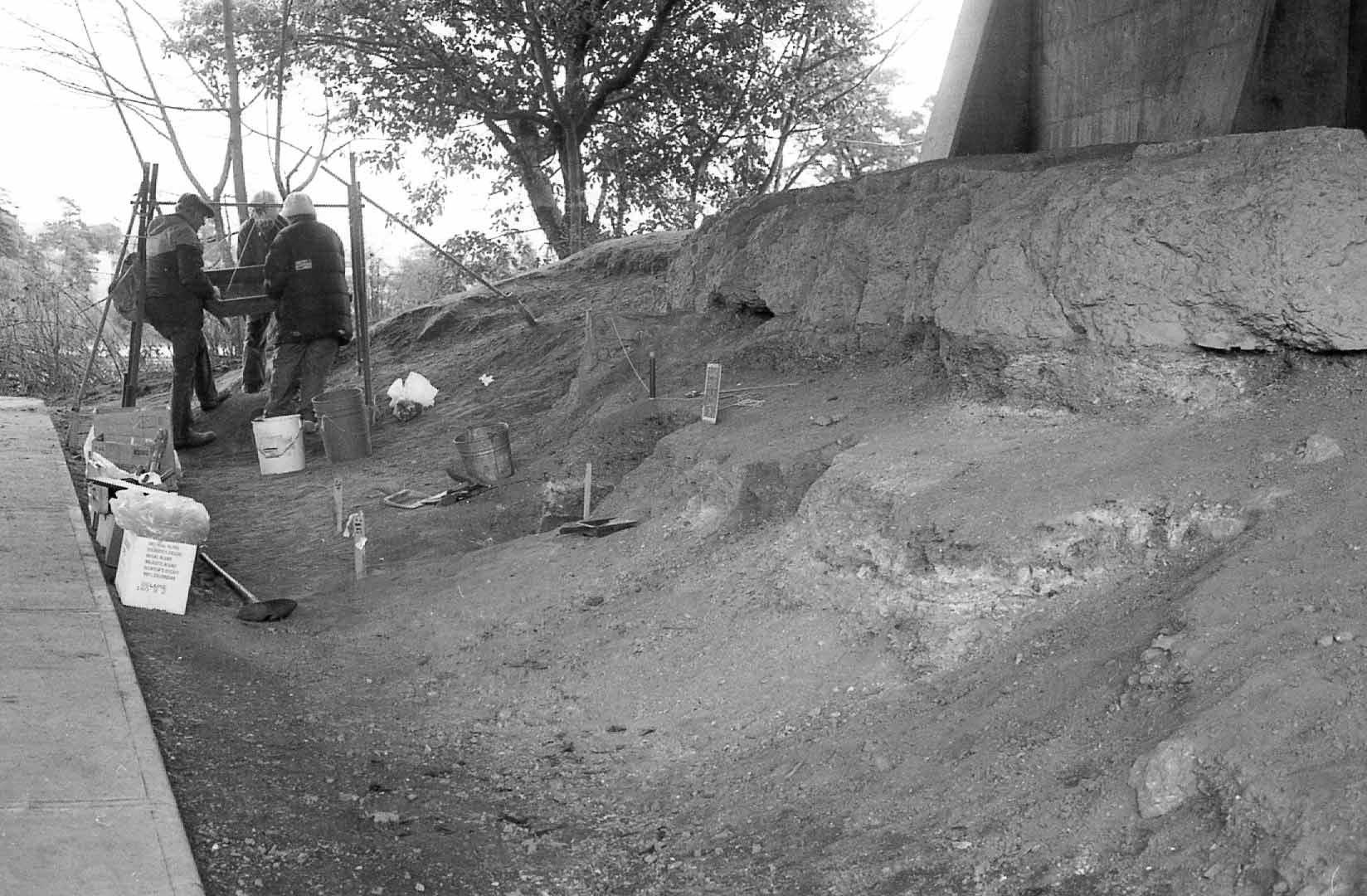
Figure 6. Looking East across the ridge of midden. Area A is in foreground and Area B is at the distant end of the ridge. On the left is the lookout walkway. The new walkway extends alongside this one and at right angles from the far end of this walk up the slope past the N. E. corner of the bridge abutment on the top right. The large cement slab base of an earlier bridge is seen with compressed and disturbed midden extending .30-.40m below it. Pit #1 is at the centre of the photo marked by wooden pegs. It has been abandoned and work is commencing on Test Pit #2 which is an extension into the sloping midden.
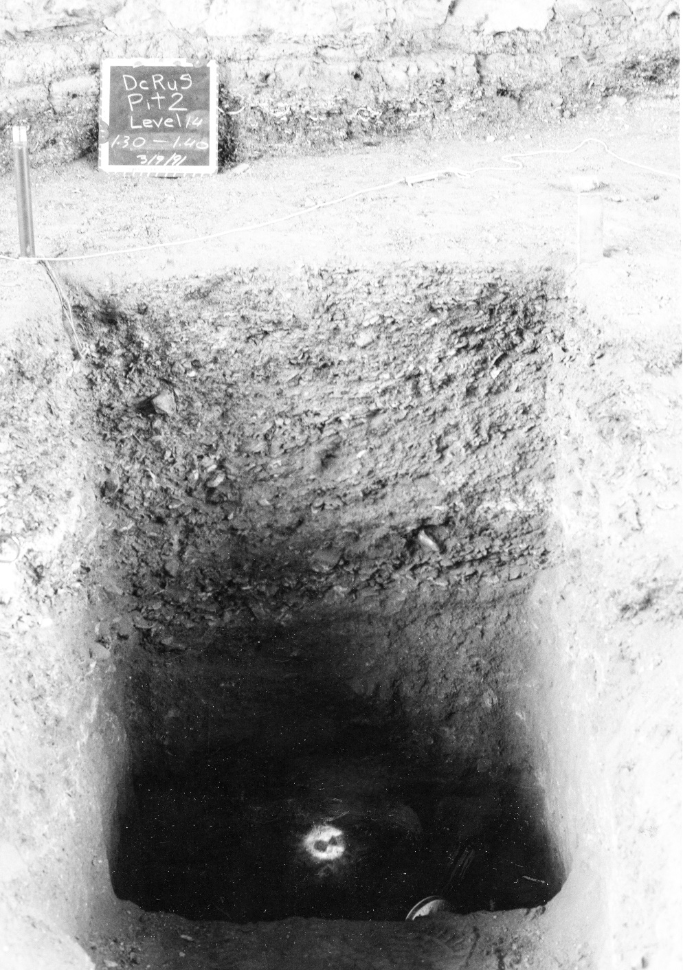
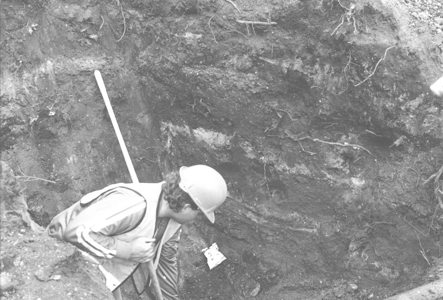
Figure 7. The Stratigraphy of Test Pit #2, looking south, level 14, 1.30m-1.40 m below datum. Zone A is the upper Zone of concentrated shell remains. The thin dark matrix layer containing heavy root concentrations is seen immediately below the shell at the top of Zone B. Disturbed and compressed midden can be seen above the test pit and below the old cement bridge support pad.
Four artifacts were found in Zone A: DcRu 5:8, level 1; DcRu 5:9, level 2; DcRu 5:10, level 6; DcRu 5:11, level 7 (see Appendix C).
Below .70m and extending to at least 1.4m below the surface was a second Zone B. The base of the cultural deposits was not reached. This lower darker zone contained only small quantities of shellfish remains compared to the upper Zone A. The shell remains were highly crushed but sporadic whole oxyster shells were found.
The upper 5cm of this zone seems to represent a hiatus period. Old root systems are concentrated here. Elongate formations of compact powdered white material is associated with the roots. This is an unidentified material related to the rotting of the roots. The same rootlets are found in lower levels but not in the same concentration. The soil colour is 5Y 4/1 and changes to 5Y 3/1 and then 5Y 3/4 at .90m below the surface. Small (under 1cm) round beach pebbles are scattered in the deposits of Zone B below .80m. These are not found in Zone A in such numbers but Zone A does contain some small as well as larger (2-3cm) pebbles.
Faunal bone remains from Zone B include: 3 dog fish; 1 probable salmon; 2 bird leg bones; 6 probable deer leg bone fragments and a small land mammal rib bone. No herring remains were found in this Zone.
Two artifacts where found in Zone B: DcRu-5: 12 – a small ground stone decorative object in level 8 and DcRu-5:13 – a stone flake in level 12 (see Appendix 3).
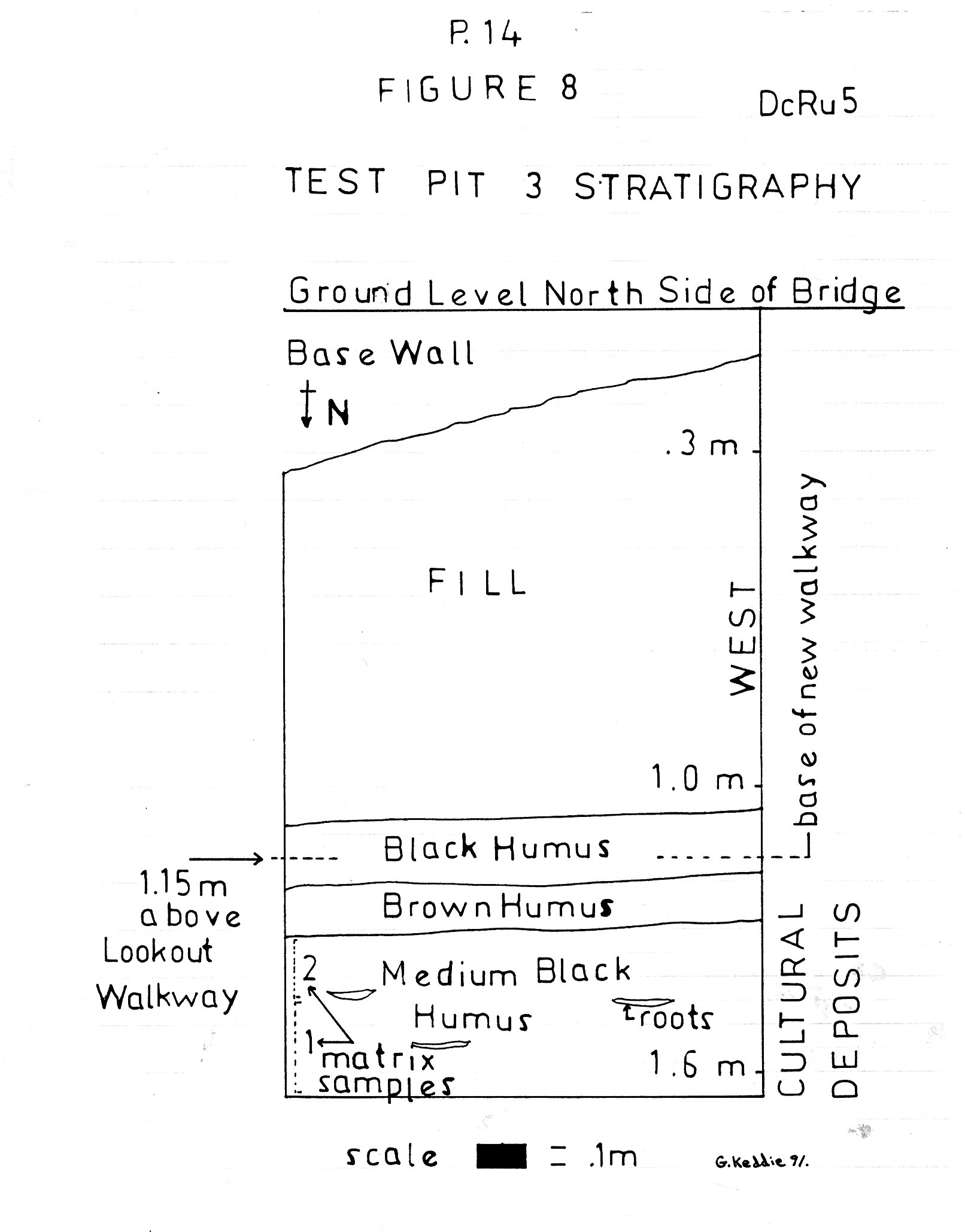
EXCAVATION OF TEST PIT #3
No further excavations were necessary in the area of Test Pit #2 as it could be determined that the intact upslope midden deposits would be just missed by the sidewalk extension.
During the construction of the sidewalk bed on the East side of the bridge a 1m by 1m backhoe (upper part) and shovel (lower part) Test Pit #3 was dug on the pathway 2.5m out from the corner of the abutment on the slope of the bank to determine the upper extent of the intact midden (Figure 8). The upper .40m-.60m of the test hole consisted of rubble fill and highly disturbed midden. Below this was .60m of intact midden. It could be determined by this that only the top .10m of intact deposits would be disturbed by the lowering of the ground level for sidewalk construction over a maximum distance of 3m.
I extracted bulk soil samples from the walls of this test pit and was able to determine that the stratigraphy corresponded to the two Zone distinctions made in test pit #2 to the west of this location.
RESEARCH DISCUSSION
The most valuable information obtained from the test pit excavations is the defining of two major Zones in the site deposits with a possible period of site abandonment at the juncture of these Zones. We did not reach the base of the cultural deposits. These extend well below the dated layer and are probably in the order of 5000 or more years in age.
The occurrence of larger numbers of small rounded beach pebbles in the lower Zone B suggests that the local shoreline environment may have been different than that of the present. Possibly before the siltation buildup in the Gorge over the last few thousand years, deeper waters allowed for the creation of more pebble beaches, similar to those, for example, that can be seen at the upper end of Esquimalt harbour. This may also account for the smaller quantities of mollusca in Zone B which prefer mud beaches. Studies by Harold Foster (1972) have shown
that the rate of sediment deposition in the Gorge has been about 1 meter every thousand years with a 4 fold increase since European settlement.
Present information indicates that the upper Gorge waterway was a fresh water stream during the early occupation of the South Gorge Bridge site because of lower sea levels at that time. The lack of immediately available mollusc resources may account for the sparse amount of shell in the lower zone of the deposits.
The charcoal sample was taken from a then existing cut 4 meters west of Pit 2. The exact relationship of this sample below the top of the dark Zone B cannot be determined in relation to the top of in excavation pit 2, because it was below the top of Zone B with possible part of this zone missing. It can be estimated to be about 10-30cm below the top of Zone B in excavation pit 2.
Portage Inlet is known to have been a fresh water basin from 9250 to 5000 years ago (Foster 1972). A date of 4120 years ago on peat in a low area now 150 meters inland from Portage inlet but extending into it has evidence of intertidal zone activity above it. This would suggest that ocean tides did not reach the upper end of Portage inlet until after about 4000 years ago.
There is an unknown hiatus until 2300 years ago when marine sediments are present in Portage Inlet. Peat materials at the base (3 meters below present surface) of Cadboro bay Gyro Park date to about 4000 years ago and suggest that the top 1 meter of deposits have built up in the last 2000 years. This would indicate that sea level was stable close to (not less than 1/2 m. below sea level) that of today for about 2000 years but it could have fluctuated between marine and fresh water over last 3000 years (Clague et al 1990). A date of 4000 years ago (plus or minus 200 years) from deposits in what was once James Bay (where the Empress hotel is today) indicates that at this time the ocean waters were higher than 4 m below present sea level.
Present data would suggest that sea level was 1 to 2 meters lower than present between about 4000 and 3000 years ago. A drop in sea level of only 1.5 m would result in ocean waters not going west of the Gorge Falls.
The archaeological evidence of differences in prehistoric resource use between Zone A and Zone B of this site should be evident if the boundary between the Zones marks a period of presence and absence of marine waters in the immediate area.
The tentative occurrence of herring fish remains only in the upper Zone A of Pit 2 is intriguing. Herring would not ascend the gorge waterway during its earlier occupation because of the absence of salt water. The bone sample size is very small and further testing is needed to confirm that Herring are not found in the lower Zone B.
The evidence found at the South Gorge Bridge Site may be a factor in determining more precisely when the shoreline reached its present level and thus provide crucial information for interpreting why prehistoric human settlements occur where and when they do in this region.
The five basalt flake artifacts from the site tell us that stone tools were being manufactured here. The small rectangular ground steatite object with two holes in it is probably an ornamental object used as decoration. This artifact helps confirm the age of Zone B, as this type of artifact has not been found in sites dating within the last 2000 years. These objects, often referred to as whatzits, are found in large and older sites more commonly dating between 3000 and 4000 years ago.
RESULTS
The test excavations undertaken during this project indicated that very minimal damage would and did occur during the sidewalk development. Due to the fact that the small area of intact midden below the bridge was the only undisturbed midden left at the East end of the site, and that this significantly old component of the midden may only occur at this location, it was necessary to ensure the protection of the remaining midden. On March 25, 1991, I was asked to give a presentation to the Esquimalt Council at which they passed a resolution to spend the funds to have the endangered portion of the midden enclosed in a 6 meter high steel link fence (see Times-Colonist, March 27). Most of the midden is now enclosed inside the fenced off area with the exception of some possibly intact sub-surface deposits extending out 2m on the west side of the cage.
This small but old section of the site is now protected for future research. Its unique location will also provide a good opportunity for the development of the site for public information display purposes.
ACKNOWLEDGEMENTS
The following have all contributed to varying degrees to the success of this project. Employees of the Corporation of the Township of Esquimalt: Richard V. Nordlund, Director, and Norman Pugh, Deputy Director, Planning and Engineering Services. Jack Boutillier, Director, Parks and Recreation Services and the Parks and Recreation Committee. Henry Sherman, Parks Foreman. Gladys Durrant, Chairperson and Bob Seright treasurer, Heritage Advisory Committee for the Township of Esquimalt. Mayor Ron Warder and Council for the Municipality of Esquimalt. Steve Acheson of the Archaeology Branch.
Volunteer Excavators from the Victoria Branch of the Archaeological Society of B.C.: Joe Baur, Louis Baycroft, Steven Coe, John Smogyi-Cismari, Tom Bown.
BIBLIOGRAPHY
Clague, John J. and Peter T. Bobrowsky. 1990. Holocene sea level change and crustal deformation, southwestern British Columbia. Current Research, Part E, Geological Survey of Canada, Paper 90-1E, p. 245-250.
Clague, John J. 1980. Late Quaternary geology and geochronology of British Columbia. Part 1: Radiocarbon dates. Geological Survey of Canada, Paper 80-13, p.14.
Foster, Harold D. 1972. Geomorphology and water resource management: Portage Inlet, a case study on Vancouver Island; Canadian Geographer, v. 16, pp. 128-143.
Keddie, Grant 1991. Spirit Divers and Spirited Diggers. The Midden, Publication of the Archaeological Society of British Columbia, Vo. 23, No.3, pp. Cover, 6-7.
APPENDIX 1. 1991-17 Report.
FAUNAL REMAINS from TEST PIT #2.
ZONE A
Level 1 (.0-.10m) 10 herring vertabrea; 1 dogfish; 1 surf perch mouth part; 1 crab claw; 2 bird leg bone fragments; 1 land mammal leg bone fragment; 1 mammal epiphysis fragment and 2 small mammal foot bones; 2 unidentified bones. (This level only contains all bones from matrix samples as well as screen sample).
Level 2 (.10-.20m) 2 herring vertabrea.
Level 3 (.20-.30m) 2 herring vertabrea; 2 dogfish vertabrea; 1 (greenling/sculpin ?); 1 bird leg bone; 3 landmammal (deer?) leg bone fragments.
Level 4 (.30-.40m) 6 herring vertabrea; 3 land mammal (deer?) leg bone fragments; 3 crab claws.
Level 5 (.40-.50) 10 herring vertabrea; 3 crab claws.
Level 6 (.50-.60m) 14 herring vertabrea; 2 herring prootics; 1 (salmon ?); 1 crab claw; 1 bird bone.
Level 7 (.60-.70m) 17 herring vertabrea; 2 dogfish; 1 salmon; 3 (greenling/sculpin?); 1 small bird pelvis.
ZONE B
Level 8 (.70-.80m) 2 bird leg bones; 1 land mammal (deer?) leg bone fragment.
Level 9 (.80-.90m) Nil.
Level 10 (.90-1.0) 1 dog fish.
Level 11 1 dog fish vertabrea; 2 land mammal (deer?) leg bones.
Level 12 1 dog fish vertabrea.
Level 13 1 dog fish; 1 (salmon?); 1 small land mammal rib, 3 land mammal (deer?) leg bone fragments.
Level 14 2 fish prootics; 2 (salmon ?) vertabrea; 1 unidentified fish vertabrea; 1 fish denturary; 1 mammal rib bone fragment.
APPENDIX 2. 1991-17 Report
[I identified more faunal remains after I turned in my 1991-17 report. Noted below].
REMAINS OF MOLLUSC and OTHER SHORE RESOURCES FROM PIT 2, LEVEL 1, Depth .0-.10m).
Specimen Weight
Oyster 6397.6 g. (minimum number of valves is 700 – these valves weight 842.8 g; other fragments 5554.8 g).
Bay mussel 236.0 g (minimum number of valves 857).
Native little neck clams 261.4 g (minimum number of valves 75).
Bent nose clam 43.3 g (minimum number of valves 41).
Cockle clam 57.0 g (minimum number of valves 1).
Horse clam 1.6 g (minimun number of valves 1).
unidentified horse and butter clams 20.9 g (minimum number 1).
California mussel .5 g (1 fragment).
Periwinkles 15.2 g (232 specimens of 2 types with some minute whelks included).
Barnacles 31.1 g (68 fragments, only a few large enough to have come from specimens large enough to eat).
Chitons 6.8 g (10 sections represented).
Limpets 8.4 g (77 specimens, too small to eat).
Welks .7 g (4 fragments).
Sea Urchin 6.9 g (300 fragments, average size .8 x .4cm).
INSECT REMAINS. Beetle. (1 head).
***Additions to Appendix 2 of Permit report 1991-17.
Pit 2 Level 5. Depth .40-.50m
Unidentified shell 5600 grams.
Oyster 2240 grams (460 unmbos)
Bay mussel 260 grams (230 values).
Bent nose clams 260 grams (72 valves).
Native little neck 172 grams (20 valves)
Cockle 30 grams (4 valves)
Barnacle 7.4 grams
Chiton 9.6 grams (12 secments)
Limpets 7.2 grams (24 too small to eat)
Snails 2.4 grams (8 small spiral)
Sea Urchin 3.6 grams.
Remains of Mollusc from Pit 2, Level 11, Depth 1.0 m-1.10 m.
Oyster 281.4 gm
Bayy Mussel 18.46 gm (26 umbos)
Native little neck clams 31.3 gm (5 umbos 10gm, others 21.1gm)
Bent noes clam 17.2gm (5 umbos)
Cockle clam 10.2gm (1only)
Horse clam 2.79gm (1 valve)
Butter or horse clams. 24.9gm
Unidentified 778.9gm
Sea urchin 0.6gm
Welks 0.3g (1only)
Snails 0.88g (4) Too small to eat
Limpets 0.06g (2) Too small to eat
Remains of Mollusc and other shore resources from Pit 2, Level 13.
Depth 1.2 to 1.3 meters.
Oyster 441.5 g.
Bay Mussel 35.5 g.
Native Little neck clams 126.0 g.
Bent Nose clam 16.6 g.
Cockle clam 14 g.
Horse clam 8.2 g.
Unidentified butter or horse clam 60.6 g.
Unidentifiable shell 1120 g.
Periwinkles (8 small specimens only)
Chiton 1.6 g.
Welk 2.4 g. (of eatable size)
Sea Urchin 2.2 g.
APPENDIX 3. 1991-17 Report.
ARTIFACT DESCRIPTION
DcRu-5:8 Small flat black basalt flake (2.3cm x 1.7cm x .4cm) with a thin line of cortex along one lateral edge which exhibits earlier flake removal across the surface perpendicular to the direction of the blow which removed the flake.
DcRu-5:9 A medium size black basalt flake (4.6cm x 2.4 x .9cm) with a distinct dorsal ridge. Shows internal glossy surface and heat spalling on ventral surface typical of heated treated basalt. This is probably one of several flakes that sheared off a heat treated core when struct. The bulbous end shows no sign of impact.
DcRu-5:10 Small baslalt flake (3.1cm x 1.9cm x .7cm) with dorsal ridge. Cortex along part of one side of dorsal surface. Large bulbar scare on ventral surface.
DcRu-5:11 Small triangular basalt flake fragment (1.6cm x .9cm x .4cm). No cortex. Similar to flake mid-section pieces resulting from bi-polar percussion.
DcRu-5:12 A ground flat, rectangular steatite object (3.1cm x 1.7cm x 1.0cm) with a hole perforated near each end on the flat surface. One surface is slghtly concave and one slightly convex. The outer opening of the drilled holes is .4cm and the narrower inner part is .3cm. Width between the holes is 1.4cm. This is called a Gulf Island Complex artifact and is similar to Duff’s E 5 type (Report of the Provincial Museum for the Year 1955, p.D49). From level 8, 70-80cm DBS.
DcRu-5:13 Small irregular basalt flake (2.3cm x 1.4cm x 1.1cm). Cortex on one flat surface. Appears to be section of bi-polar core remnant.
INFORMATION UPDATE. DcRu-5. Grant Keddie December 8, 1995.
On November 27, 1995 I was contacted by Phil Plotnickov, Superintendent of Public Works in the Municipality of Esquimalt. Public works were doing tests for evaluating the need for seismic upgrading on the Tillicum Bridge.
The area to be tested was inside the wire cage built to protect an older remnant of archaeological site DcRu-5. The location where one of the test holes was to be dug was an area of the shellmidden I knew from previous examination (permit 1991-17) to be disturbed by bridge building activities.
On December 8, 1995 I oversaw and assisted in a shovel excavation of a 1m by .9m hole adjacent to the cement wall of the bridge. This area is located between the two western cement buttresses which extend .9m out from the large cement wall which forms the southern base of the bridge.
The test hole contained mostly rock rubble. Only a few glass and porcelain fragments, dating to the mid twentieth century, and a few very tiny patches of mixed shell midden was observed scattered in the fill. Bedrock was reached at the east side of the test hole at 1.32m below the present surface and extended upward to the west for about .5m at the west side of the test hole. (See attached map for test hole location).
Appendix 2.
Notes on Archaeological Activities at the North Gorge Bridge Site, DcRu-7.
by Grant Keddie. July 17, 1990.
This site was first reported by Harlan I. Smith in 1907 from observations made earlier. Smith noted that “Following the north side of the Gorge … from the Gorge bridge to the Craigflower Bridge, a distance of more than a mile, there is an almost continuous shell-ridge. This is composed largely of pure shell material, of which in places more than half is of the oyster.” (Smith 1907, p.355). One artifact from this location, DcRu-7:11, was donated to the Provincial Museum in 1911. In February 1959 the site was officially recorded by Robert S. Kidd as part of a Provincial Museum survey of local areas. Kidd recorded the site as only including the 300 and 400 block Gorge Road, although “Traces were apparent across from 666 Gorge Rd. … and 492 Gorge Rd.” At this time kid recorded shell midden observed on the high area east of the Gorge bridge as a separate site. With the introduction of the Borden site designation system these localities were recorded as DcRu-7 and DcRu-8.
In late July of 1972, the municipality of Saanich dug up large quantities of shell midden along the Gorge from Dysart Drive to Gorge View for the construction of a sidewalk and sea wall. From July to September 1972 John Sendy of the Provincial Museum collected artifacts from disturbed areas of the site. Other Museum staff visited the location on August 1, collected artifacts from and photographed large piles of bulldozed midden and areas levelled for the sidewalk. A total of 49 artifacts (DcRu:1-10;12-50) were collected from the Dysart to Gorge View road area south of the Gorge Road. In 1973-74 another 61 artifacts were surface collected in this area by Mrs. J. F. L. Carl. These are in her private collection but are recorded at the Royal B.C. Museum as DcRu-7: 51, 61 -121. The last 9, DcRu7:122-130, are not recorded as to type.
Between 1977 and 1986 I collected 17 artifacts from the eroded bank along the south edge of lots 12 to 3 that extend east of #365 Gorge Road (DcRu-7:131-141; 143; 145-148) and 1 (DcRu-7:149) from 30 m. east of the Gorge Bridge. Tom Bown found a nipple-top hand maul (recorded as DcRu7:144) at the extreme east end of the site on the spit exposed at low tide in the small bay just east of the Gorge Bridge. An iron harpoon (DcRu-7:142) was mistakenly recorded as being from this site. It was found during sidewalk construction at the corner of Gorge Road and Qu’Appele street.
On September 20-21, 1975 after fill landscaping and grass planting had obscured the continuity of the western end of the site and without knowledge of some of the previous observations, a site survey team of Steve Acheson and Kelvin Claxton recorded a small visible part of the western end of the site as a new site DcRu-110. The bulk of the central part of the site was accurately recorded at this time based on what was observable in 1975.
On January 6, 1978, after examining previous Provincial Museum records and observing many minor landscaping and construction activities from 1974 to 1977, I updated the site form and eliminated the DcRu8 and DcRu110 records as these were only parts of DcRu7.
It is clear that Tillicum Road was constructed though the site. The shallow midden in this area was bulldozed beyond the boundary of the road to the west and subsequent fill and erosion has obscured the continuity of the site. The 1m to 1.5 m deep shellmidden deposits visible in the embankment about 50 meters west of the bridge become shallower toward Tillicum Road and are only .10 m and less on the high knoll above the east side of Tillicum Road.
At present this area is mostly covered with undergrowth but has suffered from, at least, near surface disturbance by gardening and landscaping activities since the 1860’s. This is the location of what was once known (1867-1887) as the Gorge retreat and then the Victoria Gardens. A photograph taken by Richard Maynard in 1890 (BCARS photo #F6690) shows this area with a partially protected shore embankment, and lawn areas extending back about 20 meters from the shoreline (see Wilks 1980, p.68-69). Although the shoreline has eroded considerably in the last 100 years, this area appears to be the most intact portion of the site. Midden can be seen in the cut bank extending to a maximum depth of 1.6 m.
From 1978 to 1990 I again made observations of landscaping and construction projects that resulted in the present map of the site boundaries.
On June 29, 1989 Tom Bown and myself made a presentation to the Saanich Parks Committee to promote awareness for the need to preserve the intact parts of this site. Most of the property on the south side of the Gorge Road between Gorge View and Tillicum was purchased by the Municipality of Saanich for park expansion and public access to the Gorge Waterway.
Dave Deshane of the Saanich Parks department contacted me in regard to the removal of houses from Lot 14 at #385 and Lot 13 at #365 Gorge Road. On February 24, 1990, I examined the two lots at #365 and #385 Gorge Road. I undertook soil core tests where the ground was soft enough to do so. Midden was exposed to a depth of .30 m. across the entire front of lot 13 but a close examination revealed small pieces of copper wire, rubber and round headed nails and intrusive clays extending to the bottom of these deposits. It appeared that the front lawn deposits were those removed during the construction of the house and bulldozed toward the Gorge. Extensive disturbance of midden deposits has occurred over much of these properties. In some areas, however, fill and garbage may have covered over deeper intact deposits. On lot 14 there may be some intact areas near the large arbutus tree in the southeast corner of the lot and under the hard compact driveway fill along the east side of the house.
On July 13, 1990 I went under the house at #365 Gorge Road (lot 13) via the internal trap door and examined the deposits under the east centre of the house. Seventy centimetres of disturbed cultural deposits were exposed on a 1.3 m north wall, an east exposure of 1.7 m and a west exposure extending l.7 m and around to form a northern exposure reaching the house wall to the west. On the surface was .15 m of hard brown clay similar to the non-cultural material at the base of the deposits. Although there where layered shell and ash lenses these were clearly bulldozed into place as evidenced by the finding of round headed nails, pieces of cardboard and small hardpan clay lumps extending to the bottom of the deposits.
During August 1990 I observed the removal of houses from lot 13 and 14. I was able to confirm that the cultural deposits in the area were disturbed. Large concentrations of burnt and unburnt shellfish remains, pockets of fish bone, a few mammal bones and one fragment of a human humerus were observed.
On October 23, 1989 I observed the excavation of a 3 m. by 2 m. backhoe excavation for a sewer hook-up at the S. W. corner of #482 Gorge Road on the municipal boulevard. The location was 8 m. from the sidewalk and 36 m. from the Gorge waters. At this location there was a 1.2 m. exposure of cultural material above the hardpan clay. The upper .40 m. to .50 m was disturbed mixed shellmidden and noncultural soils. The lower portions were intact. These were composed mostly of charcoal stained, sandy soil with fire broken rock and scattered shell. One concentrated shell layer extended across the upper undisturbed deposits and 2 distinct .10 m ash lenses occurred in the zone zone .10 m. to .30 m above the base of the cultural deposits. A charcoal sample was taken from soil removed .20 m above the base adjacent to an ash lens. Photographs of the stratigraphy were taken. A radiocarbon determination of the sample was undertaken. The sample (SFU 786) produced a calibrated date of 950 B.P. with a range of 992 B.P. to 904 B.P. or 1000 A.D. with a range of 958 A.D. to 1046 A.D.
On April 24, 1990 I observed midden north of Gorge Road on lot 11 at 344 Gorge Road after the excavations for a house foundation had been completed. Charcoal stained, sandy loam with fire cracked rock and intermittent scatters of shellfish remains extended 26 m. north of the south property line and could be seen to extend into the adjoining lots 10 and 12 to a depth of .30 m. The midden lays directly on a bedrock ridge and slope which extends across the mid-point of this lot 11 about 3 meters above Gorge Road. The upper limit of the site above sea level would be about 4.5 m. based on the approximate relationship to an elevation mark of 2.70 m. at the sewer grate on the N.W. corner of Tillicum and Gorge Road.
In May, 1990 a trench for a new waterline was dug to a depth of about 1.2 meters below the roadway from Tillicum Road west on Gorge Road to lot 10 at #350 Gorge. Sparce midden was observed at the base of the trench south of #350 to lot 10 at #340 Gorge Road but not to the east of this location. Bulldozing and subsequent road fill may be responsible for removing some of the midden from this area in the past.
On the south side of the Gorge dumped fill has covered the midden deposits from Gorge View Road East to lot 14. Midden is continually being covered and exposed by erosion around the water drainage culvert on lot 8A about 33 m. west of lot 14 and on lots 7A and 6A at, respectively, 38 m. and 45 m. from lot 14. Along this area and further to the east to the Gorge bridge sections of the bank have flipped over and have subsequently been eroded over by clay deposits giving the appearance of buried cultural horizons. This is a natural process and not the result of older cultural deposits being buried over time.
Cultural Contents of Site
The quantity of shellfish remains varies throughout the site but is most concentrated near the Gorge waterway shoreline. Fire broken rock is common throughout the site areas observed. In the undisturbed exposed banks and in all of the disturbed areas of the site observed the native oyster is the dominant shellfish species present followed by native little neck, butter clam, cockle, bent nose clam and bay mussel.
The Artifacts
Artifacts that did not end up in Museum collections were reported being found in the Victoria Gardens part of the site, owned by Dodd and Deans, as early as September 6, 1874. From a quick preliminary examination of the 141 artifacts found at this site (minus the 9 with no type description), 99 can be classed as tool making and fabrication equipment. That is, implements utilized primarily in the alteration or assembling of raw materials for use in the various stages of manufacture of other implements and the waste material from these activities. These include: 26 unidentifiable ground bone objects; 10 pieces of worked elk or deer antler, 15 sandstone abraders; 1 sandstone saw; 11 bone ulna tools; 6 retouched basalt flakes; 9 stone waste flakes; 2 stone core fragments; 3 bifacially flaked knives; 1 hammerstone; and mainly for woodworking, 12 antler wedges; 1 adze blade and 1 nipple-top handmaul.
Subsistence artifacts used for the direct procurement and processing of food form the second major class. The 30 items include:12 bone points; 8 bone unilaterally barbed arrow, spear or harpoon points; 7 ground slate knives or fragments; 1 composite antler harpoon valve and 2 flaked stone bifaces.
A third class of wealth, status or ceremonial artifacts includes one canis canine tooth with a circular groove and 1 fragment of a pecten shell that may have served as part of a rattle.
References to appendix 2.
Smith, Harlan I. 1907. Memoirs of the American Museum of Natural History, Vol. IV, part VI, Archaeology of the Gulf of Georgia and Puget Sound (reprint from Vol. II, part VI, of the Jessup North Pacific Expedition), London, E.J. Brill Ltd., Printers and Publishers.
Wilkes, Claire Weissman. 1980. The Magic Box. The Eccentric Genius of Hannah Maynard Photographer 1834-1918 Canada. Exile Editions Ltd. Toronto.