Hedley Cave Site DhRa-2

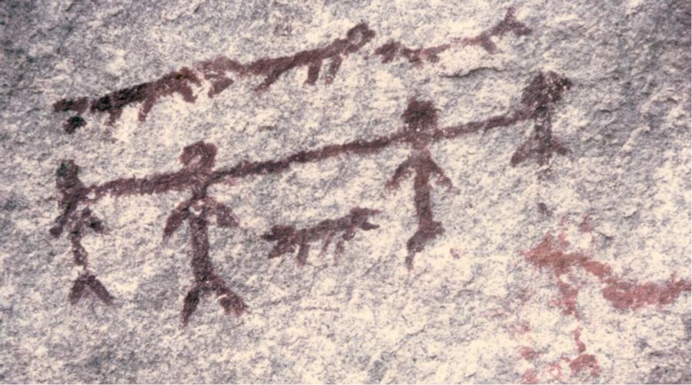
2005. By Grant Keddie The Chuchawaytha Rock Shelter Pictographs. Since reading the Midden article by Darius Kruger (2005), I thought I should add some unique information to his favorite ancestral site – the Chuchawaytha Rock Shelter, DhRa-2. This Similkameen region site has been referred to in earlier literature as the Hedley cave site. There has been some confusion regarding this location perpetuated by non-First Nation stories about early visits by Spaniards. Two clusters of images referred to as “the horseback riders” and “the prisoners” have often been misinterpreted by non-First Nations, as a single unit that represents Spaniards on horseback with ropes tied around the necks of a group of First Nation prisoners. This interpretation is an attempt by non-First Nations to fit these images with … Continue reading “Hedley Cave Site DhRa-2”

Where is Urban Archaeology?

Originally Published in Discovery: Friends of the British Columbia Provincial Museum Quarterly Review, 15(3). By Grant Keddie.  July 1987. Introduction   “Diggers Uncover Bottle Bonanza” read the headline of a Victoria newspaper in October 1981. The article explained that “Excavators have struck it rich while dig­ging at the lawn bowling club beside Crystal Gardens”. There were, in fact, many interesting bottles and ceramic items found by the work crew excavating the foundation for the new clubhouse. But were these really a surprising discovery as the newspaper article seems to suggest? The answer is, of course, no! It was a well-known fact that this area was once the shoreline of James Bay. The area was often referred to around the turn … Continue reading “Where is Urban Archaeology?”

Victoria Underwater

January 15, 2019 By Grant Keddie The Haultain Valley 14 meter Ocean Standstill. At the end of the ice age the land, in relation to the sea level, was undergoing enormous changes around Greater Victoria. Where the land surface was covered by ice or had ice sheets nearby, it was pushed down making local sea level high in relation to the land. This was occurring even when world-wide sea levels were much lower. As ice melted the local earth’s crust quickly rebounded and relative sea level fell at least 45 meters below where it is today. The sea then slowly came back up to near its present level around 4500 years ago – creating Victoria harbour, Esquimalt harbour and the … Continue reading “Victoria Underwater”

The Late lce Age of Southern Vancouver Island

Originally published in The Midden 11(4), 16-22. October 1979. By Grant Keddie A radio carbon date of 17,000 B,P. on a mammoth bone, the first date from the Saanichton Gravels north of Victoria, provides new evidence that alters the previously suggested timing of glacial events on southern Vancouver Island. The precise timing of these glacial events is of importance for archaeologists because the events define the times during which animal and human populations could have inhabited the Island. The purpose of this paper is to give a brief overview of what is known about the last stages of the Wisconsin glacial period on southern Vancouver Island; to show how the new radiocarbon date fits into the sequence of events; and … Continue reading “The Late lce Age of Southern Vancouver Island”

Concretions

1998. By Grant Keddie INTRODUCTION They assume fantastic and complex forms. They look like an exotic fossil, an animal carved by an ancient artist or something from another planet. One of the most common items that arouse excitement in people, and which are brought frequently to Museums for identification, are sedimentary stone structures called concretions. They are widespread and found in a great variety of unusual shapes – that range in size from a garden pea to giant spheroidal balls three meters in diameter. The joining or inter-growth of several elongate or disc shaped concretions often produce a kind of symmetry which, to the untrained eye, suggests they must have been made by human hands. Concretions are natural objects which … Continue reading “Concretions”

The Legend of Camosun

Originally published in: Discovery: Friends of the Royal British Columbia Museum Quarterly Review, 4(5). By Grant Keddie.  Autumn 1991. Introduction  The location of the reversible falls on the Gorge waterway in Victoria is significant in the history of Vancouver Island’s Songhees Indians. The legend of this beautiful spot under the Tillicum Road bridge produced the name of the city’s Camosun College, and was the first name for the Victoria area used by both Indians and fur traders. In 1843, James Douglas of the Hudson’s Bay Company referred to the waterway from Victoria Harbour to Portage Inlet as “Camosack”. The new fur-trade post was called “Fort Camosack”, and then “Fort Albert”, before it officially became “Fort Victoria”. Camosack was an interpretation … Continue reading “The Legend of Camosun”

Victoria’s Early Hospital Properties

Originally published in Discovery: Friends of the Royal British Columbia Museum Quarterly Review, 19(3), 4-5. By Grant Keddie. Summer 1991. Introduction In the early 1850s, temporary locations – usually private homes – served as Victoria’s first public hospitals. People who were declared insane were put with prisoners in the Public Jail. In 1853, Governor James Douglas was ordered to construct what became Vancouver Island’s first real hospital, the Esquimalt Naval Hospital. It was established for wounded British veterans of the Crimean War. The Crimean soldiers never came, but the hospital eventually was used in Esquimalt as a naval hospital. In 1858, Reverend Edward Cridge argued that “We ought immediately to unite and found a hospital, and an asylum and having … Continue reading “Victoria’s Early Hospital Properties”

Ulna Bone Tools

Originally published in The Midden, 44(3/4). Ulna Bone Tools: Identifying Their Function By Grant Keddie. 2012. Ulna tools have several main uses that are often not recognized in the archaeological literature. Based on my own experi­mental uses and an examination of the ethnographic literature, we can describe at least four different common uses of ulna tools. Ulna bones, which are the lower limb bones in animals, have a naturally shaped end that functions as a handle with little or no modification needed, and the pointed end is easy to shape into a functioning tool. The working ends of these tools need to be dif­ferent to fit the intended function. Non-ulna bones with similar ends may, of course, have similar functions. … Continue reading “Ulna Bone Tools”

Stone Cultural Feature in Thunderbird Park

By Grant Keddie.  22-02-2013. Introduction At the Royal B.C. Museum, in Victoria, British Columbia, a large natural stone with a shallow concave surface can be seen outside in the native plant garden near the North-East corner of Thunderbird Park (Figure 1 & 2).     This is a cultural object associated with First Nations that was once located south of Kamloops in the Southern Interior of British Columbia. The recorded details of its history are somewhat confusing. The natural shallow depression on the top of the rock fills with water when it rains, often forming unique patterns on the surface of the water. One could speculate that it may have been used like a mirror (Figure 3). During light rainfalls, … Continue reading “Stone Cultural Feature in Thunderbird Park”

The Atlatl Weapon

By Grant Keddie. 1988. Introduction The atlatl (pronounced at-ul-at-ul) is a fascinating weapon, used long before the bow and arrow. An atlatl is made of wood or antler, often thin and flat, and ranges from 30 cm to 1 meter in length. One end is held in the hand while the butt of a light spear is placed in a surface groove at the other end. At the end of the groove is a raised spur or attached pin to hold the bottom of the spear in place while it is held in a slightly raised position by the same hand that holds the handle end of the atlatl. Using the leverage of this short board, which functioned like an … Continue reading “The Atlatl Weapon”